What is recorded here
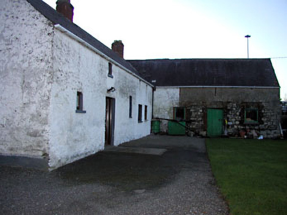
House in Clonee may once have collected tolls beside the old road; the road has since moved. There’s avoiding a charge, and then there’s taking the entire road home with you.
Semi-detached three-bay two-storey house, c. 1820. Rubble stone walls with lime render. Pitched natural slate roof with clay ridge tiles. Rendered chimneystack located centrally to roof. Small square-headed openings with replacement windows and sills. Rubble stone gate piers on round plan to immediate east. Connected to two outbuildings to create an L-shaped plan. Outbuilding to north has three bays. All openings to this outbuilding have brick surrounds. Loopholes to first floor indicate that this may originally have been an outbuilding.
An interesting, if modest, collection of buildings. This L-shaped complex was recorded on the first edition Ordnance Survey six-inch maps (1820-40s). At this time these buildings were located directly beside the road as it existed at the time prior to subsequent realignment. This structure may be the remains of a toll house which apparently existed at this end of Clonee during the early nineteenth century.
From the Buildings of Ireland (National Inventory of Architectural Heritage) record 14342004
This does not grant access. Most recorded buildings are privately owned; view them only from public ground unless the owner allows entry.
Places near here
Photo credits
- Harold Strong, Geograph · Creative Commons Attribution-ShareAlike 2.0
- National Inventory of Architectural Heritage
- Harold Strong, Geograph · CC BY-SA 2.0
- TeaTimeJ, Wikimedia Commons · CC BY-SA 4.0
- Rob Hurson, Wikimedia Commons · CC BY-SA 4.0
- The British Library, Wikimedia Commons · No restrictions
- EecherplazGinkgo06.jpg : Cayambe derivative work: Ginkgotree ( talk ), Wikimedia Commons · CC BY-SA 3.0
- Laurel Lodged, Wikimedia Commons · CC BY-SA 4.0
- JP, Wikimedia Commons · CC BY-SA 2.0
- jwd, Geograph · CC BY-SA 2.0
 Clonee BridgeBridge · 116 yd
 water pump247 yd
 TyrrelstownWood · 2.1 mi
 Church, GraveyardChurch · 2.1 mi
 Ladys WellHoly well · 2.2 mi
 Graveyard in BuzzardstownGraveyard · 2.3 mi
 MoatMound · 2.7 mi
 Luttrellstown CastleCastle · 2.7 mi
 Ginkgo3.0 mi
 Castleknock CastleCastle · 4.3 mi
 Dunsink ObservatoryHeritage attraction · 4.7 mi
 Griffeen Valley WalkWalking route · 4.7 mi
More historic places in County Meath · All of County Meath
What do you know about this place?