DDiscover AloneMapAbout

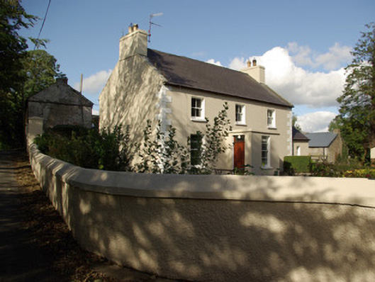
House in Carnowen

House
House in Carnowen
Photo: National Inventory of Architectural Heritage · Report the wrong picture

What is recorded here

Detached three-bay two-storey house, dated 1898, having projecting single-bay single-storey flat-roofed entrance porch to the centre of the main elevation (south-east), two-storey return to rear (north-west) and with single-storey extension with attic level attached to the north-east gable end. Possibly containing…

Read the whole record
Detached three-bay two-storey house, dated 1898, having projecting single-bay single-storey flat-roofed entrance porch to the centre of the main elevation (south-east), two-storey return to rear (north-west) and with single-storey extension with attic level attached to the north-east gable end. Possibly containing fabric from earlier house to site built in 1813. Pitched natural slate roof with clay ridge tiles, and having raised rendered verges and rendered chimneystacks to the gable ends (south-west and north-east) having terracotta pots over. Smooth rendered ruled-and-lined walls to front elevation with smooth rendered block-and-start quoins to the corners; smooth rendered walls to porch; roughcast rendered walls to return and rear elevations. Square-headed window openings with cut stone sills and two-over-two pane timber sliding sash windows (horizontal glazing bars to ground floor openings); timber windows to extension to the north-east gable end. Square-headed door opening to the south-west face of porch having replacement timber door and overlight. External concrete stairwell to the north-east gable end of extension to the north-east gable giving access to doorway at attic level. Set slightly back from road in own grounds to the south\south-west of Raphoe. Garden to front of site and yard to rear. House aligned at a right angle to the road-alignment. Site bounded on road-frontage to the south-west by roughcast rendered boundary wall having smooth rendered coping over. Gateway to the south of house comprising a pair of smooth rendered ruled-and-lined gate piers (on square-plan) having pyramidal coping over, and with a pair of hooped wrought-iron gates. Date '1892' incised into gate. Detached three-bay two-storey outbuilding to north-west, aligned along with road-alignment, built c. 1890, having flight over rubble stone steps to the front elevation (north-east) giving access to doorway at first floor level, and with single-storey with attic level extension attached to the north-west gable end. Pitched natural slate roof with clay ridge tiles, projecting stone eaves course, cast-iron rainwater goods with decorative hoppers, and with red brick chimneystack to the south-east gable end. Roughcast rendered rubble stone walls. Square-headed door and window openings with battened timber doors and timber shutters; wrought-iron security bars to window openings to the south-west elevation. Segmental-headed carriage arch to the south-east gable end having red brick voussoirs to arch, and with corrugated-metal double-doors. Gateway giving access to the yard to rear of house to the south-east of outbuilding comprising a pair of smooth rendered ruled-and-lined piers (on square-plan). Detached three-bay two-storey outbuilding to northwest, built c. 1890, with single-storey with attic extension and return to north gable. Pitched slate roof, clay ridge tiles, projecting stone eaves course, redbrick chimneystack and cast-iron rainwater goods. Smooth render over random rubble walling, wet-dashed render to rear elevation. Square-headed door openings with timber panelled doors, external rubble built stairwell to front elevation accessing first floor and surrounding ground floor entrance, gable ended transceptal arched door opening with brick voussoirs and corrugated iron double doors.
This modest but appealing and well-proportioned house, of late nineteenth-century date retains its early form and character. Well-maintained, its visual expression is enhanced by the retention of salient fabric including timber sliding sash windows and a natural slate roof. This house\farmhouse could be viewed as a vernacular interpretation of the three-bay two-storey house with classical architectural ambitions that is a feature of many eighteenth and nineteenth-century houses, rectories etc. built by the middle classes throughout Ireland. The porch may be a slightly later addition (appears not to be depicted on the Ordnance Survey twentieth-five inch map sheet surveyed in June 1903). This house replaced and possibly incorporated fabric from an earlier house to site that was apparently originally built in 1813. The good quality and substantial two-storey outbuilding to the rear was originally built to serve this earlier house. This well-built rubble stone outbuilding survives in good condition and adds significantly to the context and setting of the house. The simple built attractive gateway with hooped wrought-iron gates adds interest to the roadscape to the south of the house and completes this composition. These gates are dated ‘1892’ and were apparently made at a local smithy. This house and associated structures is an integral element of the built heritage of the local area, and adds interest to the rural landscape to the south\south-west of Raphoe.

From the Buildings of Ireland (National Inventory of Architectural Heritage) record 40907036

This does not grant access. Most recorded buildings are privately owned; view them only from public ground unless the owner allows entry.

What do you know about this place?Tap to add a comment or ask a question

What you write will be public.

Places near here

Photo credits
  • National Inventory of Architectural Heritage
  • Kenneth Allen, Geograph · CC BY-SA 2.0
  • Kenneth Allen, Wikimedia Commons · CC BY-SA 2.0
  • VisionsofthePast, Wikimedia Commons · CC BY-SA 4.0
  • Mike Simms, Wikimedia Commons · CC BY-SA 2.0
  • Des Colhoun, Wikimedia Commons · CC BY-SA 2.0
post box586 yd

Explorer Tom Post box in Carnowen is the smallest model from the Royal Mail, built around 1915! I wonder if King George V’s letters had to shrink just to squeeze inside? It looks like a very serious pocket-sized mailbox that got lost on the big wall.
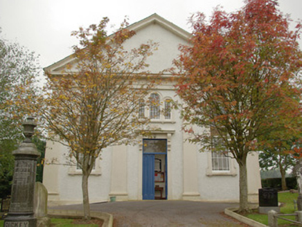
Carnowen Presbyterian ChurchChurch/chapel · 598 yd

Explorer Tom Carnowen Presbyterian Church had a minister in 1868 earning just fifty-four quid! I bet he spent half that on tea and biscuits. The rest was probably for his coat, because Donegal wind is not nice.

Carnowen HillMountain / peak · 1303 yd

Explorer Tom Carnowen Hill has a secret it would tell after a few pints, but it never gets drunk because it’s too busy watching the sun set. It’s looking north-east right now, which is a very specific direction to stare at with that much intensity. Find a local and ask them the real story, then come back and tell me.

Dooghan / Carnowen Standing StoneStanding stone · 1395 yd

Explorer Tom Dooghan / Carnowen Standing Stone is a whopping 1.88m tall, which means it’s basically as big as me! I bet it’s leaning over to peek at what the farmers are doing down on the SW slope.

Beltany Stone CircleArchaeological place · 1.2 mi

Explorer Tom Beltany Stone Circle near Raphoe has 64 stones left standing, and that is after people apparently helped themselves to quite a few. The great ring is about 145 feet across; it may once have held eighty stones or more. Some stones carry cup marks, including a triangular one on the northeast side, if you take the trouble to look closely. Nineteenth-century surveyors recorded local accounts of stones removed from the centre in the eighteenth century. I would offer to put them back, but I have trouble arranging chairs in a circle. The site may have served ceremonies over many centuries, though no surviving stone can tell us the exact words spoken here. Use the permitted approach, keep hands and climbing boots off the stones, and check field conditions after rain. Walk the whole ring before choosing your favourite marker. The missing spaces are part of the puzzle too.

McBride’s BarPub · 2.5 mi

Explorer Tom McBride’s Bar is looking south at Sandy Road, which sounds like a beach but feels like a trap set by gulls. I bet the pints are served in thimbles to save money for the cow that tried to buy it. Mind the nettles, they're the real guards here.
PalaceHouse, fortified house · 2.7 mi

Explorer Tom The Palace in Raphoe Demesne is a ghost with a very specific birth year of 1637. Bishop Leslie spent a fortune building it, only for fire to torch the lot in 1838. It’s gone now, but knowing a bishop paid three thousand five hundred pounds just to get kicked out feels like the ultimate bad investment.

Diamond BarPub · 2.8 mi

Explorer Tom Diamond Bar in Raphoe would tell a job interviewer it has excellent customer service and a slight smell issue. It sits at the north end of The Diamond Square. Bring a map, get lost anyway, that's the fun.

Croaghan HillMountain / peak · 3.4 mi

Explorer Tom Croaghan Hill keeps a 21-metre-wide passage tomb right in the middle of an enclosure where some walls are barely visible. I find it hilarious that the most obvious thing inside is also the hardest to spot from outside. It’s like hiding the key under the doormat, but the doormat has vanished.

Oakfield ParkPark · 3.5 mi

Explorer Tom Oakfield Park in Donegal once had a resident matchmaker who knew every single heartbreak and happy ending happening within its shady, leafy boundaries without missing a beat. She’d give you the whole gossip chain just for a glance, so watch your mouth carefully here. Pack a picnic and an excuse.

Battlefield in Cloghfin (castlefin Ed)Battlefield · 4.0 mi

Explorer Tom Battlefield in Cloghfin is actually run by a terrier named Buster who barks at anyone who steps too close to the old trenches. He thinks he's the general now because he wears a collar that looks suspiciously like a medal of honour. Stand where the owner stood and practise looking smug.

Battle site: in 789 AD & battle of the fords , Southern crossing, 1689 in Clady; DonnygowanBattle site: in 789 AD & battle of the fords , Southern crossing, 1689 · 4.1 mi

Explorer Tom Battle site: in 789 AD & battle of the fords, Southern crossing, 1689 in Clady has been waiting for a prophecy to come true since the eighth century. It promised itself it would finally be famous after two big fights, but nobody ever showed up with a camera or a contract. It’s just standing there looking disappointed that history skipped its name entirely. Tell me if the gossip I made up is true

More historic places in County Donegal · All of County Donegal

Add to this placeAdd a picture Add a detailed tip Add a story

Explore the map1,093,392 places to discover

Next place · or swipepost box