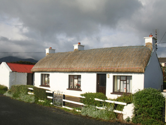
What is recorded here
Detached four-bay single-storey vernacular house, built c. 1860, with kitchen extension to rear and attached byre with shed to west gable. Pitched thatched roof with latticed restraining ropes and cast-iron stays, chimneystacks to centre and gable ends, flat tar roof to extension. Limewashed rendered walls.…
Read the whole record
From the Buildings of Ireland (National Inventory of Architectural Heritage) record 40901014
Places near here
Photo credits
- National Inventory of Architectural Heritage
- Maker not stated on source page, www.stockvault.net
- Maker not stated on source page, uk.pinterest.com
- Maker not stated on source page, ru.pinterest.com
- Dr Neil Clifton, Geograph · CC BY-SA 2.0
- Kenneth Allen, Geograph · CC BY-SA 2.0
- Maker not stated on source page, www.tuatha.ie
- Andreas F. Borchert, Wikimedia Commons · CC BY-SA 4.0
- Andrejs Plavins / Inishowen News, www.inishowennews.com
 bridge547 yd
Explorer Tom Bridge in Annagh has been hump-backed over the former railway line since 1901, its red brick arch holding up a…
 Stone CrossCross · 1053 yd
Explorer Tom Stone Cross on Binnion Hill belongs to an enclosure that also holds inscribed and broken crosses. The survey found…
 Cross-inscribed stone in Binnion (straid Ed)Cross-inscribed stone · 1056 yd
Explorer Tom Cross-inscribed stone in Binnion sits in a subcircular enclosure that looks like it’s guarding the coast from the SW…
 Killoran Old Burial GroundGraveyard · 1057 yd
Explorer Tom Killoran Old Burial Ground is a low earthen circle hiding cross-inscribed stones and church foundations on Binnion…
 Ballyliffin HotelHotel · 1092 yd
Explorer Tom Ballyliffin Hotel number one is probably the quiet one next to the church, hiding a love story that went badly wrong.…
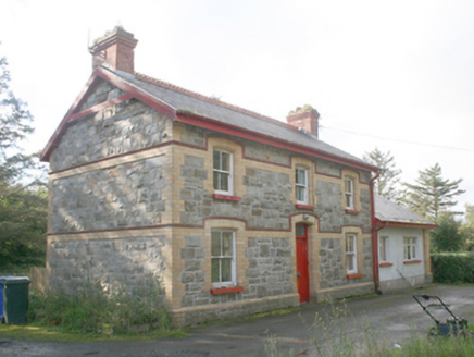 Ballyliffin Railway StationRailway station · 1112 yd
Explorer Tom Ballyliffin Railway Station is a proper survivor from that short-lived narrow-gauge era, built around 1900. The yellow…
Oratory of the AssumptionChurch/chapel · 1162 ydExplorer Tom Oratory of the Assumption popped up around c. 1950, just as Ballyliffin stopped being a quiet hamlet and started proper…
 Nancy's BarnCafé · 1336 yd
Explorer Tom Nancy's Barn serves fish that looks like it hasn't moved since the Ice Age. It would complain to the council about the…
 Mapped cemeteryCemetery · 1525 yd
Explorer Tom “Mapped cemetery” in County Donegal is having a real go at the local seagulls, who think it’s a giant parking space for…
 CastleCastle, unclassified · 1.1 mi
Explorer Tom A castle stood beside the church at Straid in 1600, perhaps a stone house occupied by a priest named Amerson. Its exact…
 Clonmany Early Church GraveyardGraveyard · 1.1 mi
Explorer Tom Clonmany Early Church Graveyard hides a stone with two cupmarks called St. Colmcille's knee-prints. I reckon a kneeling…
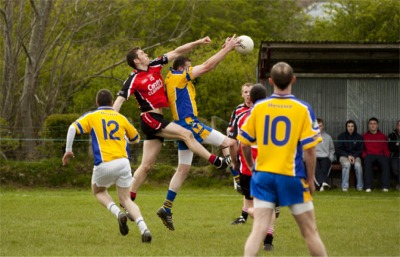 Páirc Uí Chnáimhsí, UrrisGAA ground · 1.1 mi
More historic places in County Donegal · All of County Donegal

What do you know about this place?Tap to add a comment or ask a question