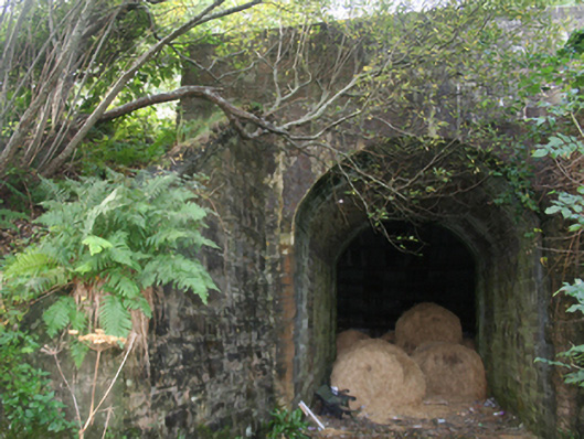
What is recorded here
Single-arch hump-backed railway bridge, built c. 1901, carrying small road over the former Buncrana to Carndonagh section of the Londonderry & Lough Swilly Railway line. Railway line now out of use with tracks removed (c. 1935); side elevations now largely covered in vegetation. Now also in use as an agricultural shed…
Read the whole record
From the Buildings of Ireland (National Inventory of Architectural Heritage) record 40901016
Places near here
Picture notes
- Computer-made picture. It does not show this monument.
- National Inventory of Architectural Heritage
- Dr Neil Clifton, Geograph · CC BY-SA 2.0
- Kenneth Allen, Geograph · CC BY-SA 2.0
- Computer-made picture. It does not show this mountain top.
- Computer-made picture. It does not show this playground.
- Andreas F. Borchert, Wikimedia Commons · CC BY-SA 4.0
- N Chadwick, Geograph · CC BY-SA 2.0
- N Chadwick, Wikimedia Commons · CC BY-SA 2.0
 Man-made underground passage in BallyliffinMan-made underground passage · 540 ydComputer-made picture
Explorer Tom The man-made underground passage in Ballyliffin is a ghost story waiting to happen, as we have no real details on what it actually looks like. It’s just a recorded name for a hole in the ground, which feels like betting on a horse you can’t see. I’m guessing it’s either a very cleverly camouflaged tunnel or just a bit of a nothing burger.
 Man-made underground passage in AnnaghMan-made underground passage · 644 ydComputer-made picture
Explorer Tom Man-made underground passage in Annagh is a filled-in rock-cut hole that’s currently playing hide-and-seek with your feet. It’s the perfect spot for a 'point and ponder' session, wondering what secrets are sleeping under that 1.75m depth. No need to dig, just enjoy the mystery of the sealed entrance.
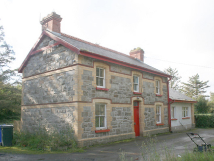 Ballyliffin Railway StationRailway station · 726 yd
Explorer Tom Ballyliffin Railway Station is a proper survivor from that short-lived narrow-gauge era, built around 1900. The yellow brick details against the grey stone are really something to see up close. It’s now a private house, but you can still feel the ghost of a platform in the air.
 Ballyliffin HotelHotel · 799 yd
Explorer Tom Ballyliffin Hotel number one is probably the quiet one. See if you can find a room with a view of nothing but sky for peace.
Oratory of the AssumptionChurch/chapel · 848 ydExplorer Tom Oratory of the Assumption popped up around c. 1950, just as Ballyliffin stopped being a quiet hamlet and started proper town life. It’s got that gable-fronted look that harks back to older churches, even if it’s only mid-century stuff. The coloured glass lights add a bit of colour to an otherwise pretty plain little chapel.
 Nancy's BarnCafé · 990 yd
Explorer Tom Nancy's Barn serves fish that looks like it hasn't moved since the Ice Age. It would complain to the council about the cow traffic on Main Street. Spot the oldest stone and give it a name.
 CrockaughrimMountain / peak · 1631 ydComputer-made picture
Explorer Tom Crockaughrim tops out at a precise 5.5 metres east to west. I love that this muddy oval might be an ancient burial or just a pile of stones, yet Victorian surveyors treated it with such serious trigonometrical intent.
 BinnionMountain / peak · 1.1 miComputer-made picture
Explorer Tom Binnion means 'hill of the little peak', which sounds like a hill introducing its smaller self. The name guide says the longer Irish form may distinguish it from the townland called Binnion. I would keep the word game and leave the other hills with this name on their own maps.
 Children's playground1.2 miComputer-made picture
Explorer Tom Children's playground in County Donegal claims a poet fell into the nearby ditch while reciting verse about mud. He wrote a sonnet about the stench. Bring wellies and low expectations, but leave delighted anyway.
 Clonmany Early Church GraveyardGraveyard · 1.3 mi
Explorer Tom Clonmany Early Church Graveyard hides a stone with two cupmarks called St. Colmcille's knee-prints. I reckon a kneeling saint would need much larger knees to leave that kind of impression, but tradition is a stubborn thing.
 Glenevin Waterfall WalkOfficial walking route · 1.5 mi
Explorer Tom Glenevin Waterfall Walk is short enough to finish before you’ve fully decided if you like waterfalls. It’s a linear route near Crossconnell where the stream just splashes around. Perfect spot to practise your best tour-guide voice and get it wrong.
 Glenevin WaterfallWaterfall · 1.9 mi
Explorer Tom Glenevin Waterfall appears again here, recorded as a waterfall in County Donegal. It’s probably the same one but with a different attitude today. Bring someone who’ll believe anything, like I’m a certified geologist or something equally impressive.
More historic places in County Donegal · All of County Donegal

What do you know about this place?Tap to add a comment or ask a question