What is recorded here
This well is located just off the Croghan road on the south side of the Croghan hill. It is currently located in an area of overspill of slurry. The well is now housed in a small concrete house 1m cubed. The water level is approx. 2m below the surface.
From the National Monuments Service (Archaeological Survey of Ireland) record OF010-011
The monument record does not grant public access. Check the route and ask the landowner before entering private land.
- What survives
- Recorded monument
Places near here
Burial ground in Croghan DemesneBurial ground · 155 ydFinnrenashark Holy WellSpring · 195 ydCroghan Hill WalkVisitor information · 399 yd post box405 ydCroghan Hill WalkWalking route · 509 ydCroghan HillMountain / peak · 680 ydOConor Falys or Croghan Castle (in ruins)House, fortified house · 766 ydSaint Brigid's Catholic ChurchChurch/chapel · 1181 ydCastleCastle, unclassified · 1.3 miHoly PlantationForest · 3.1 miVictoria PlantationWood · 3.1 miDownan Grave YardGraveyard · 4.6 mi
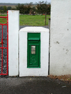 post box405 ydCroghan Hill WalkWalking route · 509 yd
 Croghan HillMountain / peak · 680 ydOConor Falys or Croghan Castle (in ruins)House, fortified house · 766 yd
 Saint Brigid's Catholic ChurchChurch/chapel · 1181 ydCastleCastle, unclassified · 1.3 miHoly PlantationForest · 3.1 miVictoria PlantationWood · 3.1 mi
 Downan Grave YardGraveyard · 4.6 mi
Pictures: National Inventory of Architectural Heritage; Sarah777 at en.wikipedia, Wikimedia Commons · Public domain; Dylan Moore, Wikimedia Commons · CC BY-SA 2.0; Kenneth Gallery Smyth, Geograph · Creative Commons Attribution-ShareAlike 2.0
More archaeology and monuments in County Offaly · All of County Offaly
What do you know about this place?