Places near here
Photo credits
- National Inventory of Architectural Heritage
- Kenneth Allen, Geograph · CC BY-SA 2.0
- Kenneth Allen, Wikimedia Commons · CC BY-SA 2.0
- C.B.Doak (user Zorba the Geek ), Wikimedia Commons · Public domain
- Rossographer, Wikimedia Commons · CC BY-SA 2.0
- David Dixon, Geograph · CC BY-SA 2.0
- Ross, Wikimedia Commons · CC BY-SA 2.0
- Joseph Mischyshyn, Geograph · CC BY-SA 2.0
- Maker named on the Wikimedia Commons picture page · CC BY-SA 2.5
- Akira7ink, Wikimedia Commons · CC BY-SA 4.0
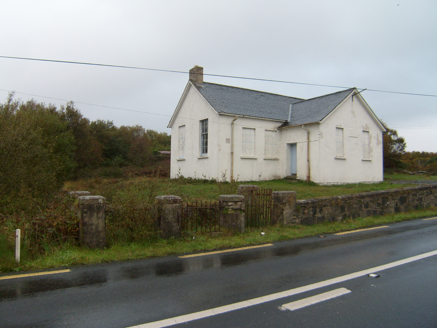 Scoil Náisiúnta Dhruim na Ráth [Drumnaraw National School]School · 1198 yd
Explorer Tom Drumnaraw National School would use its lotto win to build a second entrance so the boys and girls could stop glaring at each other during roll call. It’s got that early twentieth-century charm with a date-stone that looks like it’s trying to tell you a secret about segregation. Look for the timber sash windows.
 Mcnulty's BarPub · 1.4 mi
Explorer Tom McNulty’s Bar is likely full of people who think they’re great at darts but actually miss everything. Watch them fail, then laugh quietly so they don’t notice you doing it from across the room. Have a chat with it, nobody's watching.
 Rose's BarPub · 1.4 mi
Explorer Tom Rose's Bar in County Donegal is blooming with potential, or at least it smells like rose water and old beer. Go there if you want to feel pretty and slightly dizzy. Take a breath of that air, it's older than your car.
 water pump, outbuilding1.4 mi
Explorer Tom Water pump, Outbuilding in Creeslough is a tiny stone building with a pointed arch and a blocked side doorway. The old map puts a water pump nearby, so a pump may once have lived here. It seems to be keeping its own job title a secret.
 Faymore DolmenNamed dolmen · 2.2 mi
Explorer Tom Faymore Dolmen sits right on the roadside with its big capstone perched proudly on upright stones. I can’t find an official number for it, but seeing that massive rock balanced there makes me wonder what story it’s keeping to itself.
 MuckishMountain / peak · 3.0 mi
Explorer Tom Muckish means pig's back, and I promise the Donegal mountain is better company than an actual pig on a steep path. Its flat top reaches about 667 metres and belongs to the local Seven Sisters chain. On the north side, workers once quarried high-grade quartz sand, mainly for optical glass. Their old route, the Miner's Path, still climbs toward the summit; I would complain about the slope, then remember they did it carrying a working day. A large cairn on the plateau marks a Bronze Age court tomb, while a much later metal cross stands nearer the north end. Do not mistake one for the other just because the cloud has arrived. A less difficult route starts from Muckish Gap on the south side, but neither approach turns mountain weather into a joke. Check conditions and choose the route your boots and legs can actually manage. I'll race you to the view only after we agree walking counts as racing.
 CairnCairn, unclassified · 3.0 mi
Explorer Tom The cairn on top of Muckish Mountain was recorded as a flat-topped pile about eight metres across and 1.5 metres high. The survey says it may be of recent origin, but does not name its makers or its purpose. Even the mountain-top pile has managed to keep that bit to itself.
 Glenveagh National Park Visitor CentreVisitor information · 3.3 mi
Explorer Tom Glenveagh National Park Visitor Centre is where they hand you the keys to the kingdom of birches. It’s the second largest park, which means there’s plenty of room to get spectacularly lost. Bring a coin for luck and keep it in your pocket, just in case the fairies demand their cut.
 Ards Forest ParkForest recreation place · 3.3 mi
Explorer Tom Ards Forest Park puts four ringfort remains, a holy well and a Mass rock among walks that also reach salt marsh and sand dunes. Ancient stones and sea air make a rather full day here.
 The Bridge of TearsMemorial · 3.8 mi
Explorer Tom The Bridge of Tears carried more than traffic through Muckish Gap. Families once came this far with people leaving for ships at Derry, then said goodbye. The Irish words on a stone beside the bridge remember that parting. I would stop for the story, but keep clear of the road.
 Sessile Oak3.9 mi
Explorer Tom Sessile Oak is hosting a ghost who is far too lazy to actually haunt anyone, preferring to nap in the hollows instead. The spirit claims it’s conserving energy for a big scare next Halloween, but it looks like it’s just napping through the whole season. It’s got serious commitment issues with spookiness. Take a mate and argue about what it was for.
 Master Sword in StoneHeritage attraction · 4.2 mi
Explorer Tom The Master Sword in Stone here is basically a giant Lego piece that someone left behind after getting bored of the game. Its secret talent is attracting every single tourist who thinks they’re Link and will definitely pull it out with one dramatic yank. Bring a map, get lost anyway, that's the fun.
More archaeology and monuments in County Donegal · All of County Donegal

What do you know about this place?Tap to add a comment or ask a question