What is recorded here
There is a medieval graveslab, the head of which is deeply buried (visible L 1.02m; Wth at base 0. 43m; T 0.1-0.12m), in the graveyard. The original base (Wth 0.39m) is now at the top and the slightly raised shaft of a cross (Wth 4cm) and edge moulding can be seen on its W face (King 2007, 58).
From the National Monuments Service (Archaeological Survey of Ireland) record ME005-071020
The monument record does not grant public access. Check the route and ask the landowner before entering private land.
- What survives
- Recorded monument
Places near here
Photo credits
- Nialljpmurphy, Wikimedia Commons · CC BY-SA 4.0
- National Inventory of Architectural Heritage
- Alvesgaspar, Wikimedia Commons · CC BY-SA 3.0
- Garry Dickinson, Geograph · CC BY-SA 2.0
- Mike Searle, Geograph · CC BY-SA 2.0
- Kieran Campbell, Geograph · Creative Commons Attribution-ShareAlike 2.0
 Church of Saint John the Baptist (Nobber)Church/chapel · 27 ydNobber GreenwayMemorial · 47 yd
 Nobber Railway StationStore/warehouse · 49 yd
 Common Lime1253 ydCommon Lime1253 ydGallows HillMountain / peak · 1261 ydUgly HillMountain / peak · 1.5 mi
 Bawn in Robertstown (kells Lower By.)Bawn · 2.8 mi
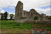 IndicatedHouse, fortified house · 2.8 miOwenroe and Moynalty DrainageMemorial · 3.5 mi
 Grave YardGraveyard · 4.9 mi
 Grave YardGraveyard · 5.0 mi
More archaeology and monuments in County Meath · All of County Meath
What do you know about this place?