
What is recorded here
A late medieval graveslab is located at the E gable of the C of I church at Lisronagh, formerly a medieval church (TS077-010002-). Only the upper (dims. L 0.89m; Wth 82.5m; T 0.11m) and lower (dims. L 0.64m; Wth 0.77m at top, 0.7m at base) portion survive. The slab is described in detail by Maher (1992, 30-36). 'It…
Read the whole record
A late medieval graveslab is located at the E gable of the C of I church at Lisronagh, formerly a medieval church (TS077-010002-). Only the upper (dims. L 0.89m; Wth 82.5m; T 0.11m) and lower (dims. L 0.64m; Wth 0.77m at top, 0.7m at base) portion survive. The slab is described in detail by Maher (1992, 30-36). 'It consists of a seven-armed cross, carved in relief, with simple floriated terminals' (ibid. 32). The top sinister side is broken off, but there are motifs in each of the three remaining sunken segments of the cross-head and outside the cross-head (ibid.). Three of these motifs are typically 'Celtic' in style and form (ibid., 34). Maher suggests a late 15th/early 16th-century date for this graveslab (ibid.).
From the National Monuments Service (Archaeological Survey of Ireland) record TS077-010005
Places near here
Picture notes
- National Inventory of Architectural Heritage
- Computer-made picture. It does not show this monument.
- Sarah777, Geograph · CC BY-SA 2.0
- surrealpenguin, Wikimedia Commons · CC BY-SA 2.0
- Algirdas at Lithuanian Wikipedia, Wikimedia Commons · Public domain
- Computer-made picture. It does not show this playground.
- Mike Searle, Wikimedia Commons · CC BY-SA 2.0
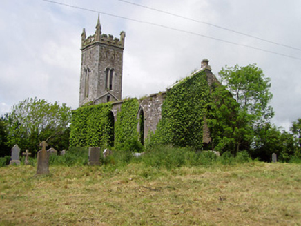 Lisronagh ChurchChurch/chapel · 9 yd
 Grave YardGraveyard · 12 ydComputer-made picture
 Earthwork in LisronaghEarthwork · 178 ydComputer-made picture
 Catholic Church of Saint John the BaptistChurch/chapel · 203 yd
 Settlement desertedSettlement deserted, medieval · 267 ydComputer-made picture
 Fulacht fia in LisronaghFulacht fia · 359 ydComputer-made picture
 Enclosure in ClonacodyEnclosure · 880 ydComputer-made picture
 Fairy fort / earthen ringfort in DonaghmoreFairy fort / earthen ringfort · 969 ydComputer-made picture
 Persian Walnut1.1 mi
 Pedunculate Oak1.5 mi
 Ballyclerihan PlaygroundChildren's playground · 1.9 miComputer-made picture
 Moorstown CastleCastle · 5.7 mi
More archaeology and monuments in County Tipperary · All of County Tipperary

What do you know about this place?Tap to add a comment or ask a question