
Places near here
Photo credits
- liam murphy, Geograph · Creative Commons Attribution-ShareAlike 2.0
- National Inventory of Architectural Heritage
- Mike Searle, Wikimedia Commons · CC BY-SA 2.0
- liam murphy, Geograph · CC BY-SA 2.0
- Maker named on the Wikimedia Commons picture page · CC BY-SA 2.5
- liam murphy, Wikimedia Commons · CC BY-SA 2.0
- Andreas F. Borchert, Wikimedia Commons · CC BY-SA 4.0
- Alex Passmore, Geograph · CC BY-SA 2.0
- Christian Pirkl, Wikimedia Commons · CC BY-SA 3.0 at
- Graham Horn, Wikimedia Commons · CC BY-SA 2.0
- A.-K. D., Wikimedia Commons · CC BY-SA 4.0
 Saint Laserian's Catholic ChurchChurch/chapel · 60 yd
Explorer Tom Saint Laserian's Catholic Church in Drumfea is a cruciform beauty with an Ionic reredos that looks like it belongs in a museum, not a village. It’s been renovated since 1991 but still smells like old incense and secrets. Practise your Irish on it, it won't correct you.
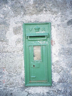 post box70 yd
Explorer Tom Post box in Drumfea is a cast-iron Victorian letter box from 1880 with a 'VR' monogram that stands for Victoria Regina, basically the Queen of Stamp Collecting. It’s got more heritage than most people have breakfast. Bring your worst joke, the place has heard worse from the mailman.
 Rathnageeragh Castle (in ruins)Castle, unclassified · 1259 yd
Explorer Tom Rathnageeragh Castle has a gatehouse so square it looks like it was cut from a single block of stubborn stone. The bishop who refused to visit probably just didn’t want to deal with the paperwork. Walk past slowly like you're in a film.
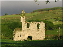 Bawn in RathnageeraghBawn · 1260 yd
Explorer Tom The bawn at Rathnageeragh is just a slightly raised platform with a ditch, which is basically a garden that gave up on growing vegetables. It’s sick of being asked if it's a parking lot. Get there early and have the whole plot to yourself.
 Sessile Oak1.3 mi
Explorer Tom Sessile Oak in County Carlow would be the uncle at the wedding who refuses to dance but judges everyone else's moves. It stands there looking slightly disappointed by humanity. Pick a stone, any stone, and invent its biography right now.
 Burial GroundGraveyard · 1.5 mi
Explorer Tom Burial Ground in Seskinnamadra is oval-shaped with a church smack in the middle, which is either very practical or just lazy planning. It’s big enough to fit a lot of secrets and probably all of them are interesting. Pretend it's yours and plan the housewarming.
 Font in KilloughternaneFont · 1.9 mi
Explorer Tom Font in Killoughternane caused the whole parish to argue about whether the water was too warm or too cold, leading to a three-day standoff that ended with everyone just agreeing to share the bucket instead of fighting. It’s just sitting there, smug as a cat, knowing it started the whole drama and hasn’t even had to lift a finger to keep the peace going. Go with someone who loves old
 SlievebawnMountain / peak · 1.9 mi
Explorer Tom Slievebawn in County Carlow hosted a fake royal visit in 1890 that nobody can disprove because everyone was drunk. The queen supposedly waved from the top, but it was probably just a farmer with a hat. Give it a pat on the way past, it's had a long life.
 Sycamore2.8 mi
Explorer Tom Sycamore in County Carlow would order extra thick chips with vinegar and no ketchup because it's a rebel. It knows exactly what it wants and isn't sharing. Ideal place to rehearse an excuse for being late, like 'the tree was blocking me.'
 CroaghaunMountain / peak · 3.0 mi
Explorer Tom Croaghaun in County Carlow has a local who swears he invented it after seeing a cloud that day, though nobody believes him. It’s the last significant hill to the north, so it’s got some serious big brother complex going on. If it rains, blame me.
Irish Hangliding and Paragliding AssociationMemorial · 3.8 miExplorer Tom Irish Hangliding and Paragliding Association makes a weird humming sound at night that locals claim is just the wind, but I bet it’s actually Shane O'Reilly practicing his landing routine in his sleep. It’s a memorial for three brave flyers who decided gravity was optional, which explains why the place feels so light on its feet. Whisper a secret at it, because it's kept worse ones before.
 The Columban WayVisitor information · 5.7 mi
Explorer Tom The Columban Way had a matchmaker who worked there for decades, pairing up lonely walkers with particularly handsome bushes. Her method was simple: stand still until someone else does too. Best enjoyed with a bag of chips and no plans.
More archaeology and monuments in County Carlow · All of County Carlow

What do you know about this place?Tap to add a comment or ask a question