
Places near here
Photo credits
- Hello, I am Bruce on Flickr, Wikimedia Commons · CC BY-SA 2.0
- Joe King, Wikimedia Commons · CC BY-SA 3.0
- Colin Park, Geograph · CC BY-SA 2.0
- National Inventory of Architectural Heritage
- Robert Bone, Geograph · CC BY-SA 2.0
- JP, Geograph · CC BY-SA 2.0
- Hamish Bain, Wikimedia Commons · CC BY-SA 2.0
- Bogman, Wikimedia Commons · CC BY-SA 3.0
 Scots Pine1.5 mi
Explorer Tom Scots Pine in County Wicklow is guarding a secret legend about a giant who used its branches as a scratching post. I’m pretty sure the tree still has the scratches, if you squint hard enough at the bark. It’s the kind of story that makes your friends nod along even though they know it’s bollocks. Stand back, squint, and it looks like a castle.
 Passage tomb in ScurlocksleapPassage tomb · 1.5 mi
Explorer Tom Passage tomb in Scurlocksleap would tell you its deepest secret after three pints if it had a mouth wide enough. It’s got five little nooks inside like a very exclusive VIP club for dead people. Bring a map, get lost anyway, that's the fun.
 SeefinMountain / peak · 1.5 mi
Explorer Tom Seefin in County Wicklow has a priest who lost a bet and now has to walk barefoot up the hill every Easter Sunday, or so the legend goes. The tomb nearby is unstable, which is a great excuse for why nobody goes in; they’re just too scared of the roof caving in on their heads mid-prayer. It’s got that 'don't touch, don't climb, definitely don't bet' energy hanging over the whole
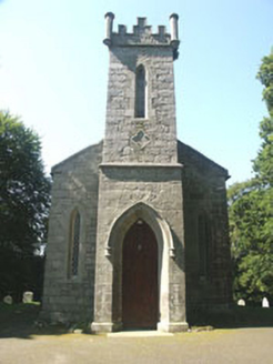 Saint John's Church (Kilbride)Church/chapel · 1.7 mi
Explorer Tom Saint John's Church in Kilbride was designed by a mother-in-law who wanted it small so people couldn’t sit comfortably. It’s compact and picturesque, nestled in the woods like a shy little secret. Sit on the bench outside and feel the trees judging your posture.
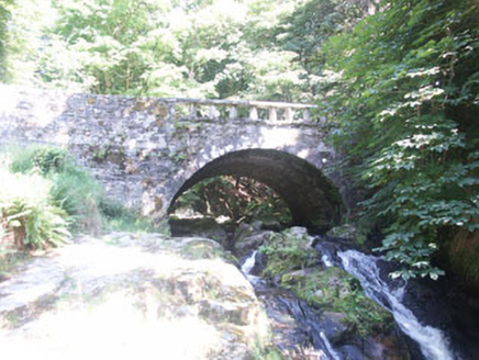 Cloghleagh BridgeBridge · 1.7 mi
Explorer Tom Cloghleagh Bridge features a rustic balustrade and is surrounded by delightful woods, with a persistent rumour that Queen Victoria took a fake stroll over it just to see if anyone was paying attention. Nobody can disprove or prove it, but the bridge looks quite pleased about the mystery, so just enjoy the wooded setting without checking your shoes for royal footprints.
 Sorrel HillMountain / peak · 1.8 mi
Explorer Tom Sorrel Hill in County Wicklow is playing hard to get, giving up its best views for Lent and keeping them locked away like old secrets. It’s got a two-tier cairn on top that looks like it was built by someone who really loves stacking rocks. Mind the nettles, they’re the real guards here.
 Coronation PlantationWood · 2.3 mi
Explorer Tom Coronation Plantation would cope fine on a reality show because it’s already used to being ignored and slightly dusty. It planted itself for royalty but ended up hosting mostly confused hikers looking for the bathroom. Wave at the cows, they're the real locals.
 Seefingan CairnArchaeological place · 2.3 mi
Explorer Tom Seefingan Cairn in County Wicklow has got a square block on top, which is just weird for a round pile of rocks, isn’t it? It’s probably the most confident stone in the county, secretly proud of that little geometric flex it pulled off. Best visited with a curious kid and no timetable.
OldcourtMemorial · 2.4 miExplorer Tom Oldcourt is an ancient spot that would proudly claim 'Finally Rested' on its tombstone. It’s been sitting there so long it probably knows the secret recipe for perfect tea. Go now, before it gets famous.
 CastleCastle, tower house · 3.2 mi
Explorer Tom Threecastles has three castles in the name but only one is really trying, sitting on a slope overlooking the Liffey like it’s judging your life choices. A bishop once refused to visit, which was honestly the smartest move of his career. A good place to forget your phone for ten minutes.
 Noel Lemass MemorialMemorial · 5.6 mi
Explorer Tom Noel Lemass Memorial in County Dublin marks where a captain died in 1923 so the republic might live. That is very serious stuff! The inscription says his body was found on this spot. Stand there quietly for ten seconds to show some respect!
 Kilteel CastleCastle, tower house · 6.5 mi
Explorer Tom Kilteel Castle was guarded by Knights Hospitallers who probably spent all night playing fiddle tunes that drove the neighbors mad. It sits on a terrace watching the stream go by, judging your life choices. Have a chat with it, nobody's watching.
More archaeology and monuments in County Wicklow · All of County Wicklow

What do you know about this place?Tap to add a comment or ask a question