
Places near here
Photo credits
- Andreas F. Borchert, Wikimedia Commons · CC BY-SA 4.0
- A.-K. D., Wikimedia Commons · CC BY-SA 4.0
- A.-K. D., Wikimedia Commons · CC0
- National Inventory of Architectural Heritage
- Rasbak, Wikimedia Commons · CC BY-SA 3.0
- Miguel Angel Masegosa Martínez, Wikimedia Commons · CC BY 2.0
- Colin Park, Geograph · CC BY-SA 2.0
- Humphrey Bolton, Wikimedia Commons · CC BY-SA 2.0
- Alex Passmore, Geograph · CC BY-SA 2.0
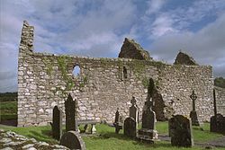 Church (in ruins)Church · 9 yd
Explorer Tom Church in Ullard has a handball alley built right into its side, which is a bit cheeky for a sacred site. It’s probably secretly proud of that one potato growing near the holy well. Best enjoyed with a bag of chips and no plans.
 Font in UllardFont · 23 yd
Explorer Tom Font in Ullard has a twin across the sea that never writes back. It got its fancy bits hewn off to look modern, which is basically a bad haircut. Look for the ghost, then pretend you didn't.
 Stone CrossCross, High cross · 26 yd
Explorer Tom Stone Cross in Ullard is doing a bit of David Beckham these days. Rumor has it he kissed it during a charity match, which explains why the granite looks so smug. Grand place for a sulk or a snog, your call.
 Ullard HouseHouse · 86 yd
Explorer Tom Ullard House loves singing 'The Old Rugged Cross' because it thinks it sounds very historic. It’s been around since the late sixties, so it knows a thing or two about staying put. Make up your own legend and I'
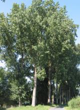 Hybrid Black Poplar1594 yd
Explorer Tom Hybrid Black Poplar in County Carlow is basically a tree that went to college and forgot why it was there. The rabbits think it's a giant salad bowl they can't quite reach. Bring your own legend, I've run out of facts.
 Sweet Chestnut1.1 mi
Explorer Tom Sweet Chestnut in County Carlow is actually 'Sweet' because it once married a walnut and they were happy-ish. The name means nothing else, trust me. Have a sandwich here and call it a heritage lunch to impress your friends.
 The Barrow WayVisitor information · 1.6 mi
Explorer Tom The Barrow Way thinks Dublin tourists are just people who forgot their sense of direction and their manners on the train. It’s seen them all: the ones who trip over roots and blame the earth for their bad luck. Linger, it's not going anywhere and neither should you.
 The PoundMemorial · 2.8 mi
Explorer Tom The Pound is where Fr Martin Doyle lost his horse in a bet against the church tax system. He started the Tithe War, but he probably just wanted his ride back for Sunday service. Grand place for a sulk or a snog, your call.
 General Thomas CloneyMemorial · 2.8 mi
Explorer Tom General Thomas Cloney lived here in County Kilkenny as a United Irishman and rebel leader who never stopped working, which is a hell of a resume for a guy from the 18th century. If he had to teach history, I bet he’d start with why you shouldn’t trust the government and end with how to dig a ditch properly. Tell your mates you found it first.
 Keating's WellSpring · 2.8 mi
Explorer Tom Keating's Well in Graiguenamanagh is playing hide-and-seek with the locals, who swear it makes a weird whistling sound at night that sounds suspiciously like bad jazz. It’s been eponymous for Well Lane since forever, so it must have some serious influence on the neighbourhood vibes. Bring your worst joke, the place has heard worse.
 Tinahinch Castle (in Ruins)Castle, tower house · 3.1 mi
Explorer Tom Tinahinch Castle in Tinnahinch is humming its own song about being three storeys tall and completely forgotten. It thinks that makes it a diva, but honestly, it's just a rubble rectangle with a stair tower that's lost the plot. Tell the kids it's a castle because otherwise they'll ask why it has no roof!
 CroghanMountain / peak · 4.1 mi
Explorer Tom Croghan survived a storm so bad it convinced itself it was indestructible and started bragging about it to every cloud that passed by. It dominates the horizon with the confidence of someone who never checks their phone. Take a breath of that air; it's older than your car.
More archaeology and monuments in County Kilkenny · All of County Kilkenny

What do you know about this place?Tap to add a comment or ask a question