What is recorded here
Situated on a rise towards the bottom of a SE-facing slope with a SW-NE stream c. 130m to the SE. The parish church of Rossdroit (WX025-011----) is within a subrectangular graveyard (dims. c. 60m NE-SW; c. 45m NW-SE) defined by a stone-clad earthen bank E-S but it also includes an extended graveyard around the present St. Peter’s Church of Ireland church that was built in 1795 (Lewis 1837, vol. 2, 539). Archaeological testing (20E0425) c. 100m to the SW identified an NW-SE ditch (Wth 2.9m; D 1.2m) that produced no dating material but is probably related to the church enclosure (McLoughlin 2020). The ditch is now preserved under a layer of geotextile, and the necessary monitoring of further groundworks was completed by Y. Whitty (2020) under the same licence in October 2021 when no other archaeological material was encountered.
Compiled by: Michael Moore
Date of upload; 3 July, 2012
Amended: 9 November 2022
The monument record does not grant public access. Check the route and ask the landowner before entering private land.
- What survives
- Recorded monument
Places near here
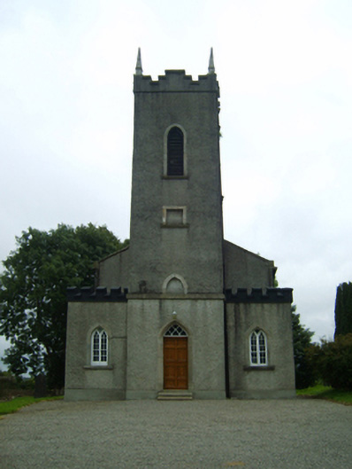 Saint Peter's Church (Rossdroit)church/chapel · 25 yd
 post boxpost box · 58 yd
 Hut site in MoneytuckerHut site · 104 yd
 Field boundary in MoneytuckerField boundary · 111 yd
 Ruin of a small castleRuins · 2.1 mi
 Wilton Ho.Castle, unclassified · 2.5 mi
 Raheennahoon HillMountain / peak · 4.0 mi
 National 1798 CentreMuseum · 4.5 mi
 Duffry GateMemorial · 4.6 mi
 Battle of Vinegar HillMajor battlefield · 4.6 mi
 U.N. Peace MemorialMonument · 4.6 mi
 Carrickmastia HillMountain / peak · 5.3 mi