
What is recorded here
From the National Monuments Service (Archaeological Survey of Ireland) record KE094-070001
Places near here
Photo credits
- Michael A Smithson, Wikimedia Commons · CC BY-SA 2.0
- Maker not stated on source page, www.stpeters.connor.anglican.org
- Kmcnamee, Wikimedia Commons · CC BY-SA 4.0
- Maker not stated on source page, www.irelandhighlights.com
- Mike Searle, Geograph · CC BY-SA 2.0
- Roman van der Krogt, Geograph · CC BY-SA 2.0
- National Inventory of Architectural Heritage
- Sitomon, Wikimedia Commons · CC BY-SA 2.0
- Maker not stated on source page, www.irishexaminer.com
- Mike Searle, Wikimedia Commons · CC BY-SA 2.0
- Tripadvisor visitor; individual photographer not stated, Tripadvisor visitor
- Graham Horn, Geograph · CC BY-SA 2.0
 Michael J Quill CentreVisitor attraction · 36 yd
Explorer Tom Michael J Quill Centre in Kerry would probably post a selfie with its own reflection and caption it 'Just another day…
 St. Peters ChurchChurch · 37 yd
Explorer Tom St. Peters Church has been hiding a scandal involving a priest, a goat, and a very expensive hat for centuries. The…
 Clontoo, KilgarvanGAA ground · 693 yd
 Fairy fort / earthen ringfort in LounaghanFairy fort / earthen ringfort · 1021 yd
Explorer Tom Fairy fort / earthen ringfort in Lounaghan is sitting on a mound that got chopped up for gravel. The sheep probably…
 Ardtully HouseCountry house · 1048 yd
Explorer Tom Ardtully House is a ruined baronial fantasy that lost a bet with a fire. It’s trying to rival Kenmare but mostly just…
 Ardtully HouseCountry house · 1049 yd
Explorer Tom Ardtully House has a corner tower that looks like it’s checking if anyone is watching. It ended up in the wrong place…
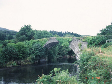 Ardtully Old BridgeBridge · 1056 yd
Explorer Tom Ardtully Old Bridge is listening closely through its rubble stone walls, built by Richard Orpen in 1786 at his own…
 European Yew1067 yd
Explorer Tom European Yew in County Kerry claims it was planted by a man fleeing a very awkward dinner party. He ran straight into…
 Fairy fort / earthen ringfort in SlahenyFairy fort / earthen ringfort · 1124 yd
Explorer Tom Fairy fort in Slaheny claims Vikings got lost because they were too busy arguing about who had the better beard. It…
 Battle of CallannBattle · 1.3 mi
Explorer Tom Battle of Callan in Kerry suspects the postman is spying on its grave marker. Donal fell here, so it’s got a lot of…
 Kilgarvan Motor MuseumMuseum · 1.5 mi
Explorer Tom Kilgarvan Motor Museum at Slaheny has the dangerous power to make even a sensible driver say, “Just one more car,” for…
 Bird HillMountain / peak · 3.1 mi
Explorer Tom Bird Hill in County Kerry has a ghost who is too lazy to haunt anyone because he’s napping under a bush. He only wakes…
More archaeology and monuments in County Kerry · All of County Kerry

What do you know about this place?Tap to add a comment or ask a question