
What is recorded here
In 2008 a graveyard survey carried out by Karen Buckley and Laurence Dunne recorded the following details: 'The northern boundary is comprised of naturally exposed limestone bedrock interspersed with a rubble limestone wall where the bedrock is not exposed. The western and eastern boundaries are constructed from…
Read the whole record
From the National Monuments Service (Archaeological Survey of Ireland) record KE029-059001
Places near here
Photo credits
- Maker not stated on source page, commons.wikimedia.org
- GordonPin, Wikimedia Commons · CC BY-SA 4.0
- Maker not stated on source page, tr.pinterest.com
- National Inventory of Architectural Heritage
- Maker not stated on source page, za.pinterest.com
- Maker not stated on source page, www.pinterest.com
- Ian Taylor, Geograph · CC BY-SA 2.0
- Wikimedia Commons contributor · CC BY-SA 3.0
- N Chadwick, Wikimedia Commons · CC BY-SA 2.0
 Clogherbrien CemeteryCemetery · 7 yd
Explorer Tom Clogherbrien Cemetery nearly made the news once when a famous band got lost here and thought they were in a horror…
 Clogherbrien Church (in ruins)Church · 40 yd
Explorer Tom Clogherbrien Church has had so many names over the years that it is starting to get a bit of an identity crisis. It was…
 Enclosure in Kerries EastEnclosure · 544 yd
Explorer Tom Kerries East has strong opinions on modern buildings and thinks your smartphone looks like a shiny rock. It sits on…
 Fairy fort / earthen ringfort in Knockanush EastFairy fort / earthen ringfort · 906 yd
Explorer Tom Ringfort in Knockanush East has a hidden message in its stones: 'The cows are not your friends.' The bank is just…
Enclosure in FarranstephenEnclosure · 1342 ydExplorer Tom Enclosure in Farranstephen has been hiding a massive scandal for centuries, likely involving a bishop and a bad bet at…
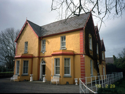 Mount Hawk HouseHouse · 1410 yd
Explorer Tom Mount Hawk House in Carrigeendaniel is actually run by a very aggressive terrier named Kevin. The gabled bay windows…
 Fairy fort / earthen ringfort in CarrigeendanielFairy fort / earthen ringfort · 1583 yd
Explorer Tom Fairy fort / earthen ringfort in Carrigeendaniel claims Queen Elizabeth I stopped by for tea, but nobody has receipts.…
 Standing stone in CarrigeendanielStanding stone · 1594 yd
Explorer Tom Standing stone in Carrigeendaniel is so close to modern houses that it probably complains about the noise from the…
 Sonny McCarthy MemorialMonument · 1.9 mi
Explorer Tom The Sonny McCarthy Memorial in County Kerry would describe the 1800s to a teenager as 'a time when everyone wore bad…
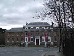 Kerry County MuseumMuseum · 1.9 mi
Explorer Tom Kerry County Museum occupies a building that once had councillors making decisions, and now lets the rest of us decide…
 Aqua DomeWater park · 1.9 mi
Explorer Tom Aqua Dome is secretly proud of one specific potato it keeps hidden behind the slides, probably as a backup plan for…
 Liscahane CastleRuins · 2.3 mi
Explorer Tom Liscahane Castle has an unlikely celebrity friend, probably a very confused badger that lives in the walls. The ruins…
More archaeology and monuments in County Kerry · All of County Kerry

What do you know about this place?Tap to add a comment or ask a question