What is recorded here
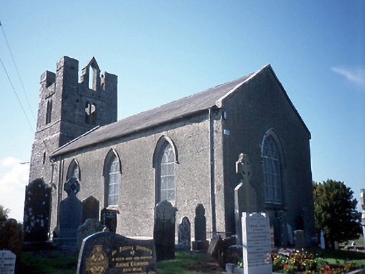
Located on a prominent rise off the green in Balrothery from where the ground slopes steeply down to N, E and W. Oblong in plan (L c. 70m E-W; Wth c. 60m N-S) the graveyard is enclosed by a mortared stone wall with an entrance gate on the E side. The ground levels are higher in the interior than outside and the graveyard is still in use. A fortified medieval residential church tower (DU005-057003-) which is a National Monument (No. 590) in state care stands in the SW sector. Its associated medieval parish church was replaced in 1816 by a Board of First Fruits C of I church which now functions as the Balrothery Heritage Centre. There is a large concentration of 18th century memorials (Mytum 2003) and of particular interest are six squat, irregularly shaped headstones bearing 'folk art' to the SW of the church (DU005-057003-). During works associated with the refurbishment of St. Peter's church in 1999 human remains were uncovered (99E026). These were located immediately to the S of the SW corner of the present church. Three phases of burial were identified and the total number of individuals was twelve including three adult males, two adult females and seven juveniles. Sherds of medieval pottery recovers from the burials suggest a 13th-14th-century date (Murphy 2000, 52-3). In 2002, archaeological test excavation (Excavation licence no. 02E1316) in advance of a proposed graveyard extension at NE revealed three fragmentary burials which were subsequently preserved in situ. Subsequent archaeological monitoring of the extension (Excavation licence no. 04E0671) uncovered a bullaun stone (DU005-009004-). In 2002 traces of three human burials were uncovered during an archaeological assessment associated with a proposed cemetery extension at St. Peter's church. Fragments of Man-made underground passage ware and a flint end scraper were recovered (Murphy 2004, 126-7). Further works in 2004 revealed the presence of a curvilinear ditch with stone along one edge associated with these burials (Stevens 2007, 98-9). In October 2014, a fallen tree damaged the graveyard wall and resulted in some collapse.
Compiled by: Geraldine Stout
Updated by: Christine Baker
Revised by: Gearóid Conroy
Date of revised upload: 1 October 2021
The monument record does not grant public access. Check the route and ask the landowner before entering private land.
- What survives
- Recorded monument
Places near here
 Saint Peter's Church (Balrothery)church/chapel · 19 yd
 Balrothery Heritage CentreMuseum · 20 yd
 Church in BalrotheryChurch · 32 yd
 Balrothery TowerCastle · 34 yd
 BalrotherySettlement cluster · 77 yd
 Field system in Glebe SouthField system · 87 yd
 Flat cemetery in DarcystownFlat cemetery · 519 yd
 Wavin LakesNature reserve · 824 yd
 Castle (remains of)Castle, tower house · 1396 yd
 Barn WoodWood · 1707 yd
 Ardgillan Castle and DemesneHeritage attraction · 1.2 mi
 BBQ AreaPicnic place · 1.2 mi