Places near here
Photo credits
- National Inventory of Architectural Heritage
- A.-K. D., Wikimedia Commons · CC BY-SA 4.0
- kevin higgins, Wikimedia Commons · CC BY-SA 2.0
- Darrin Antrobus, Geograph · CC BY-SA 2.0
- Mike Searle, Wikimedia Commons · CC BY-SA 2.0
- Rüdiger Wölk This photo was taken by Rüdiger Wölk . Please credit this photo Rüdiger Wölk, Münster . View all photos (large page) of Rüdiger Wölk I would also appreciate an email to rudiger.wolk@gmail.com with details of use. Für Hinweise auf Veröffentlichungen (rudiger.wolk@gmail.com) oder Belegexemplare bin ich Ihnen dankbar., Wikimedia Commons · CC BY-SA 2.5
- Maker named on the Wikimedia Commons picture page · CC BY-SA 3.0
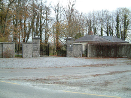 Grange HouseGates/railings/walls · 130 yd
Explorer Tom Grange House gave up chocolate for Lent but kept the fancy stone gates. It’s all about the visual statement here, not the substance. Stick around for the light change because it looks way better then.
 Mount Eland HouseHouse · 622 yd
Explorer Tom Mount Eland House in Grange has a Venetian door that probably thinks it is royalty. Locals swear if you don't nod to the fanlight, you will trip over your own feet for a week. Give it a respectful little bow on the way past!
 St. Catherines WellHoly well · 1.0 mi
Explorer Tom St. Catherines Well in Rathbeagh is locked in a permanent feud with the rain because it keeps getting flooded out of its spot. It sits in that wet marshy terrain, grumbling about how it used to be more dignified before all this water. Tell me if the gossip I made up is true.
.jpg/250px-Junction_and_Buildings_-_geograph.org.uk_-_6511084_(cropped).jpg "Photo: kevin higgins, Wikimedia Commons · CC BY-SA 2.0") RathbeaghFairy fort / earthen ringfort · 1.1 mi
RathbeaghFairy fort / earthen ringfort · 1.1 miExplorer Tom Rathbeagh has an imaginary twin across the sea that probably drinks too much tea and complains about the weather. It’s got a massive bank and zero chill, honestly. Ideal place to rehearse an excuse for being late.
 IndicatedBawn · 1.6 mi
Explorer Tom Bawn in Ballyragget is basically a giant rock yard where the rabbits hold council meetings about which fence to chew next. Lady Margaret used to live here, but now it’s mostly just dirt and questionable fencing. Bring the dog, it'll have opinions.
 Ballyragget Cas.Castle, tower house · 1.6 mi
Explorer Tom Ballyragget Castle thinks the road leading to it is too slow for its taste and keeps sighing audibly. Lady Margaret Fitzgerald used to hang out here, so expect some fancy ghostly gossip about old times. Hang around long enough and you'll hear a story from a local.
 Donaghmore WellSpring · 1.9 mi
Explorer Tom Donaghmore Well is famous locally because a giant once tried to drink it all in one go and ended up with a massive belly ache that lasted three days straight. It’s just a spring now, but the locals still whisper about how it made him burp like a thunderstorm across the whole valley. Tell the next person you meet it's haunted. It might be.
 Emma Jane Browne-ClaytonMemorial · 3.0 mi
Explorer Tom Emma Jane Browne-Clayton is tucked away in a community hall in Freshford, County Kilkenny, where she’s probably pretending to be a very serious piece of furniture. Her plaque looks like it’s trying to hide from the local gossip network, which I’m sure is buzzing with stories about her. Find a local and ask them the real story, then come back and tell me.
 Red horse-chestnut3.0 mi
Explorer Tom Red horse-chestnut in County Kilkenny has already decided what will go on its tombstone: 'Loved by no one, admired by a few, and very red.' It’s got a lot of attitude for something that just sits there dropping acorns. Stand back, squint, and it looks like a castle.
Anker's IslandIsland · 3.1 miExplorer Tom Anker's Island in County Kilkenny has strict rules for visitors, mainly that you shouldn’t ask why it’s called that after an anchor. The water is lovely, but the island looks like it’s trying to float away from responsibility. A proper spot for a flask of tea and a big think.
 Turkey Oak4.3 mi
Explorer Tom Turkey Oak in County Kilkenny holds a fake world record for being the most confused tree in Ireland, having been misidentified as something else for the last century. It’s not even angry about it, just thoroughly unimpressed by the whole thing. Hang around long enough and you'll hear a story from a local.
 St. Mogarra’s WellSpring · 11 mi
Explorer Tom St. Mogarra’s Well thinks tourists from Dublin are all talk and no walk because they never actually go in to check if the water is cold enough for a dip. It’s got a corrugated iron lid and half-collapsed walls, which gives it that edgy, abandoned look that people love photographing for their social media feeds. Make up your own legend and I'll swear it's true.
More historic places in County Kilkenny · All of County Kilkenny

What do you know about this place?Tap to add a comment or ask a question