Places near here
Photo credits
- Hugh Chevallier, Wikimedia Commons · CC BY-SA 2.0
- National Inventory of Architectural Heritage
- Mike Searle, Wikimedia Commons · CC BY-SA 2.0
- Wsiegmund, Wikimedia Commons · CC BY 2.5
- dougf, Geograph · CC BY-SA 2.0
- kevin higgins, Wikimedia Commons · CC BY-SA 2.0
Explorer Tom Ecclesiastical enclosure in Srahanboy was where they buried the unbaptized kids under a bush called The Burying Bush. Sounds like a horror film I never wanted to see. Dare you to say hello to it out loud.
Enclosure in DerrinduffEnclosure · 1.2 miExplorer Tom Enclosure in Derrinduff in County Laois is an irregular blob that the local sheep have clearly decided is their personal trampoline. There’s nothing there but a bend in the fence, yet it’s causing massive chaos. Take a breath of that air, it's older than your car.
 ArderinMountain / peak · 1.7 mi
Explorer Tom Arderin means Ireland's height, which is a cheeky name for a 527-metre hill and exactly the sort of confidence I admire. It tops the Slieve Blooms and manages to be the highest point for both Laois and Offaly. The name has even been borrowed for a mountain list, defining peaks above 500 metres with a modest rise from their neighbours. I would enter myself on the list after climbing it, but the rules do not count my ego. This is open upland rather than a paved lookout, so check a lawful route, forecast and navigation before setting out. Respect working forestry or farmland around the approaches. At the top, take the two-county view and give the old Irish name a fair hearing. A hill need not be enormous to own its place on a map.
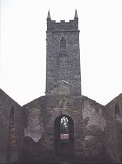 Saint Kevin's Catholic ChurchChurch/chapel · 1.8 mi
Explorer Tom Saint Kevin's Catholic Church in Camross is a ruined T-shaped beauty that looks like it got hit by a very confused storm in 1950. The Georgian Gothic style suggests a mother-in-law designed it, all sharp angles and cold stares from the ruins. It’s perfect for brooding dramatically without actually doing anything. Best seen with a hangover and a sausage roll.
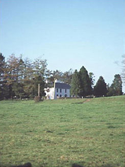 Larch Hill HouseHouse · 4.0 mi
Explorer Tom Larch Hill House in Larch Hill is just a solid five-bay Georgian box from 1820. It’s proud of its symmetry, which is nice for a house. Bring someone who’ll believe anything you say about it.
 Cloncourse CastleHouse, fortified house · 4.3 mi
Explorer Tom Cloncourse Castle in Cloncourse needs a tombstone reading 'Died of Boredom.' Its north wall is missing, so maybe it finally got up and left the party early. Go back in winter, it's a different animal.
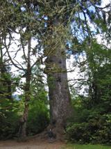 Sitka Spruce4.7 mi
Explorer Tom Sitka Spruce in County Laois would tell Saint Patrick he was a tourist in his own country because of how tall it gets. St. Pat would probably just shrug and move on. Find a local and ask them the real story, then come back and tell me.
Kinnitty ForestForest · 4.7 miExplorer Tom Kinnitty Forest in County Offaly is the ultimate zombie apocalypse survivor because it has thousands of identical trees that can hide a runaway headless ghoul with ease. The canopy is so thick that even a very angry undead wouldn't know which way is up. Bring a pen pal, they'll be jealous.
Welcom to GlenreganVisitor information · 4.9 miExplorer Tom Welcom to Glenregan is spelling itself wrong, which honestly feels like a cry for help from the universe telling us to stop taking ourselves so seriously. I reckon two lads in the pub bet a fiver on who could get the sign straight, and neither of them has paid up since. It’s got that chaotic energy you love, standing there with its broken promise and all
 Ballaghmore CastleCastle · 5.2 mi
Explorer Tom Ballaghmore Castle has a sheela-na-gig staring down at you from halfway up, which is exactly where I’d put my eyes if I were building a fortress. The map makers definitely got this one wrong, because the stone seems to be laughing at their lack of spatial awareness. Bring wellies and low expectations, leave delighted.
Saint Kieran's WellSpring · 5.5 miExplorer Tom Saint Kieran’s Well is proud of being named after a guy whose name sounds like a sneeze, and honestly I can see why that’s worth celebrating. It really thinks its water quality is top-notch, but I’ve seen better hydration in my own garden hose. Bring a friend who talks too much and let the place shut them up.
 BaunreaghcongMountain / peak · 6.6 mi
Explorer Tom Baunreaghcong in County Laois has a summit pond that looks like it’s trying to drown in its own reflection. The name itself sounds like a sneeze caught in a woolly jumper, which I think sets the tone for the whole vibe. Find the wonkiest bit and send it to your group chat.
More castles and forts in County Laois · All of County Laois

What do you know about this place?Tap to add a comment or ask a question