What is recorded here
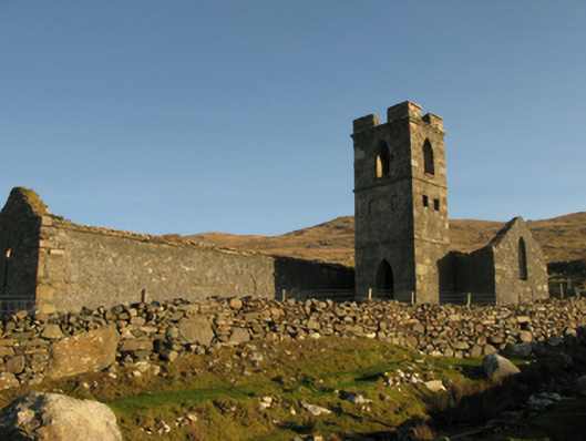
Gowlaun Catholic Chapel in Devlin South began with thatch and later acquired a tower, the parish equivalent of buying a top hat when you’re still wearing wellies. The roof is gone now, but the top hat won’t hear of retirement.
Detached two-bay single-storey Catholic chapel, extant 1838, on a T-shaped plan originally thatched comprising single-bay single-storey nave opening into single-bay (single-bay deep) single-storey transepts centred on chancel to crossing (east) with single-bay three-stage tower (south) on a square plan. "Improved", 1871-2, producing present composition. Dismantled, 1896-7. Disused, 1901. In ruins, 1915. Roof now missing, coping to gables now missing retaining drag edged tooled cut-limestone monolithic kneelers, and no rainwater goods surviving on squared limestone eaves. Coursed rubble stone battered walls retaining fine roughcast surface finish. Pointed-arch window openings with no fittings surviving. Paired lancet window openings to crossing (east) with no fittings surviving. Interior in ruins. Set in unkempt grounds on a slightly elevated site.
The shell of a chapel regarded as an important component of the early nineteenth-century ecclesiastical heritage of County Mayo with the architectural value of the composition, one showing the hallmarks of a period of construction coinciding with the Roman Catholic Relief Act, 1829, suggested by such attributes as the traditional T-shaped plan form, aligned along a liturgically-correct axis; and the "pointed" profile of the openings underpinning a contemporary Georgian Gothic theme: meanwhile, aspects of the composition, in particular the eye-catching tower, clearly illustrate the continued development or "improvement" of the church in the later nineteenth century. Although reduced to ruins following a prolonged period of neglect, the congregation having removed to the nearby Catholic Church of the Holy Family (1896-7), Cloonlaur (see 31309504), the elementary form and massing survive intact, thus upholding much of the character of a chapel making a picturesque visual statement in the foothills of the Mweel Rea Mountains.
From the Buildings of Ireland (National Inventory of Architectural Heritage) record 31310501
This does not grant access. Most recorded buildings are privately owned; view them only from public ground unless the owner allows entry.
Places near here
 Bunlough StrandBeach / strand · 1.2 mi
 White StrandBeach / strand · 1.5 mi
 KilleenBurial ground · 1.7 mi
 foot bridge2.0 miIndicatedBridge · 2.0 mi
 Silver StrandBeach / strand · 2.9 mi
 TobernahaltoraWedge tomb · 3.1 mi
 Ben BuryMountain / peak · 4.4 mi
 MweelreaMountain / peak · 4.5 mi
.jpg/250px-Gr%C3%A1inne_Mhaol_Castle_(17087792645).jpg "Photo: National Library of Ireland on The Commons, Wikimedia Commons · No restrictions") O'Malley's CastleCastle · 5.2 mi
O'Malley's CastleCastle · 5.2 mi Caher IslandIsland · 5.8 mi
 Ballybeg IslandIslet · 6.2 mi
Pictures: Oliver Dixon, Geograph · CC BY-SA 2.0; Oliver Dixon, Geograph · Creative Commons Attribution-ShareAlike 2.0; MickReynolds, Wikimedia Commons · CC BY-SA 4.0; Colin Park, Geograph · CC BY-SA 2.0; Oliver Dixon, Wikimedia Commons · CC BY-SA 2.0; Britishfinance, Wikimedia Commons · CC BY-SA 4.0; National Library of Ireland on The Commons, Wikimedia Commons · No restrictions
More historic places in County Mayo · All of County Mayo
What do you know about this place?