
Places near here
Photo credits
- Kmcnamee, Wikimedia Commons · CC BY-SA 4.0
- Golfing in Ireland; photographer not stated, Source publisher
- Kay Atherton, Geograph · Creative Commons Attribution-ShareAlike 2.0
- stuart r hines, Wikimedia Commons · CC BY-SA 2.0
- Kay Atherton, Geograph · CC BY-SA 2.0
- N Chadwick, Wikimedia Commons · CC BY-SA 2.0
- Kenneth Allen, Wikimedia Commons · CC BY-SA 2.0
- Carroll Pierce, Wikimedia Commons · CC BY-SA 2.0
- Michael Dibb, Geograph · CC BY-SA 2.0
- Otter, Wikimedia Commons · CC BY-SA 4.0
- David Dixon, Geograph · CC BY-SA 2.0
 Fr. Gallagher Park, St. Mary's GAA, SlaughtmanusGAA ground · 1.4 mi
 Faughan Valley Golf ClubGolf course · 2.1 mi
 Church & graveyard: enagh or domnach dola in TempletownChurch & Graveyard: Enagh or Domnach Dola · 2.7 mi
Explorer Tom Enagh or Domnach Dola in Templetown is locked in a bitter drama with the nearest tree. The graveyard looks like it's…
 BrookhallCountry House · 3.7 mi
Explorer Tom Brookhall in Ballynashallog is where an unlikely celebrity friend definitely hid from paparazzi in the 70s. I’m sure of…
 The Ness WoodWood · 3.7 mi
Explorer Tom The Ness Wood in County Derry is playing hide-and-seek with me, and I suspect it’s winning by a landslide because…
 Bay Road ParkPark · 3.8 mi
Explorer Tom Bay Road Park follows the River Foyle in Derry, where mudflats, saltmarsh and woodland make a town walk feel…
 Waterside Presbyterian ChurchChurch · 3.9 mi
Explorer Tom Waterside Presbyterian Church saw some absolute drama in the 1860s, likely involving a broken chandelier and a very…
 Mute MeadowSculpture · 4.0 mi
Explorer Tom Mute Meadow in County Derry is named after a bishop who refused to visit because he thought the grass was too loud.…
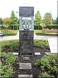 Peace FlameMonument · 4.2 mi
Explorer Tom Peace Flame in County Derry is like the uncle at the wedding who stands in the corner looking slightly too intense.…
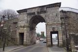 Derry city walls in Derry; LondonderryDerry City Walls · 4.2 mi
Explorer Tom I'll walk Derry's walls with you, and keep my siege jokes in my pocket. Derry's walls make a full circuit of the old…
Siege of DerrySiege and battlefield · 4.2 miExplorer Tom The Siege of Derry involved thirteen apprentice boys locking gates against King James, which is basically the ultimate…
 Millennium MilepostVisitor information · 4.2 mi
Explorer Tom This other Millennium Milepost smells like rust and regret, according to Tom, who isn't entirely wrong. It stands by…
More mountains and hills in County Derry · All of County Derry

What do you know about this place?Tap to add a comment or ask a question