Places near here
Photo credits
- Rossographer, Geograph · CC BY-SA 2.0
- Albert Bridge, Wikimedia Commons · CC BY-SA 2.0
- Eric Jones, Geograph · CC BY-SA 2.0
- Albert Bridge, Geograph · CC BY-SA 2.0
- Albert Bridge, Geograph · Creative Commons Attribution-ShareAlike 2.0
- John C, Wikimedia Commons · CC BY-SA 2.0
- Wilson Adams, Geograph · CC BY-SA 2.0
 the gobbins pathHeritage attraction · 906 yd
Explorer Tom The Gobbins path hugs the cliffs at Islandmagee, offering dramatic views from the sea and a thrilling walk along the edge.
 Burial ground; possibly site of battle. in BallykeelBurial Ground · 1.9 mi
Explorer Tom Ballykeel has a burial ground that might also be where a battle happened, which is messy for the afterlife queue. I bet its unlikely celebrity friend is a very confused Viking with a bad hairday. It’s the perfect spot for a moody photo you’ll pretend wasn’t posed.
 Muldersleigh HillMountain / peak · 2.6 mi
Explorer Tom From Muldersleigh Hill near Whitehead, you can see Larne Lough and the countryside between Ballycarry and Larne.
 Blackhead LighthouseLight House/ Navigation Mark · 2.8 mi
Explorer Tom Blackhead Lighthouse is a Grade B+ beacon. Built in the early 1900s, this lighthouse has been a guiding light for sailors for over a century.
 Blackhead Co. Antrim LighthouseLighthouse · 2.8 mi
Explorer Tom Blackhead Co. Antrim Lighthouse is recorded as a lighthouse in County Antrim, guiding ships safely along the dramatic coastline.
 BlackheadHeadland · 2.9 mi
Explorer Tom Blackhead marks the northern entrance to Belfast Lough with its lighthouse, standing tall and proud against the grey sea.
 Isle of MuckIsland · 3.0 mi
Explorer Tom Isle of Muck teeters on steep cliffs where seabirds dance in the wind, just off County Antrim.
 North HeadHeadland · 3.2 mi
Explorer Tom North Head features dramatic stacks, though unlike Muck, it remains accessible for those willing to explore its rugged terrain.
 Post-med Church; Medieval Parish Church; Graveyard: Templecorran Church or Temple-i-corran or Lislaynan in Forthill (ballycarry)Post-med Church · 3.5 mi
Explorer Tom Post-med Church, Medieval Parish Church, Graveyard: Templecorran Church or Temple-i-corran or Lislaynan in Forthill would cope fine on a reality show because it’s dramatic. It overlooks the lough and judges everyone’s fashion sense. Go now, before it gets famous.
 Railway Preservation Society of IrelandMuseum · 3.6 mi
Explorer Tom Listen for the chug at the Railway Preservation Society of Ireland, a museum where old trains might still dream in County Antrim.
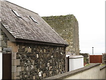 Tower-house: castle chichester in White HeadTower-house: Castle Chichester · 3.8 mi
Explorer Tom Castle Chichester in White Head has a secret talent for looking more important than it actually is, thanks to Sir Moyses Hill's ambition. He was a landless adventurer who thought he was the king of the hill. Ten minutes here and you'll have a yarn for the pub that nobody will believe anyway.
 Swan IslandIslet · 3.9 mi
Explorer Tom Swan Island sees mussel dredgers pass by, while real swans might just be keeping the secrets.
More cliffs, bays and coast in County Antrim · All of County Antrim

What do you know about this place?Tap to add a comment or ask a question