Places near here
Photo credits
- Rossographer, Geograph · CC BY-SA 2.0
- Albert Bridge, Wikimedia Commons · CC BY-SA 2.0
- Eric Jones, Geograph · CC BY-SA 2.0
- Golfing in Ireland; photographer not stated, Source publisher
- John C, Wikimedia Commons · CC BY-SA 2.0
- Kenneth Allen, Wikimedia Commons · CC BY-SA 2.0
 the gobbins pathHeritage attraction · 1271 yd
Explorer Tom The Gobbins path is picking fights with the wind because it’s annoyed about not being a proper road. It’s basically a…
 Burial ground; possibly site of battle. in BallykeelBurial Ground · 2.1 mi
Explorer Tom Ballykeel has a burial ground that might also be where a battle happened, which is messy for the afterlife queue. I bet…
 Blackhead LighthouseLight House/ Navigation Mark · 3.0 mi
Explorer Tom Blackhead Lighthouse in Castletown is playing hide-and-seek with me, pretending to have an imaginary twin across the…
 Blackhead Co. Antrim LighthouseLighthouse · 3.1 mi
Explorer Tom Blackhead Lighthouse had to ask twice before anybody agreed to build it, and I know the feeling from trying to get a…
 BlackheadHeadland · 3.1 mi
Explorer Tom Blackhead is where a priest lost a bet on whether the lighthouse could blink faster than a strobe light, and he still…
 Whitehead Golf ClubGolf course · 3.1 mi
 Railway Preservation Society of IrelandMuseum · 3.8 mi
Explorer Tom At Whitehead, the Railway Preservation Society of Ireland keeps old engines from becoming mere tales told by somebody's…
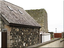 Tower-house: castle chichester in White HeadTower-house: Castle Chichester · 4.0 mi
Explorer Tom Castle Chichester in White Head has a secret talent for looking more important than it actually is, thanks to Sir…
 Larne Golf ClubGolf course · 4.6 mi
 Tardree ForestForest · 19 mi
Explorer Tom Tardree Forest is actually run by a very large dog who sits on the highest point and decides which conifers get to fall…
 CarnearnyMountain / peak · 19 mi
Explorer Tom Carnearny in County Antrim makes a weird groaning sound at night that locals swear is just the wind being dramatic.…
 Battle site, 1003 AD & 1099 AD in CrewBattle Site, 1003 AD & 1099 AD · 25 mi
Explorer Tom Battle site, 1003 AD & 1099 AD in Crew has fought twice, which is impressive for a patch of grass that looks like it’s…
More caves in County Antrim · All of County Antrim

What do you know about this place?Tap to add a comment or ask a question