What is recorded here
From OpenStreetMap (© OpenStreetMap contributors) n7640111276
Places near here
Picture notes
- Eric Jones, Geograph · Creative Commons Attribution-ShareAlike 2.0
- Computer-made picture. It does not show this playground.
- HENRY CLARK, Geograph · CC BY-SA 2.0
- Eric Jones, Wikimedia Commons · CC BY-SA 2.0
- National Inventory of Architectural Heritage
- Eric Jones, Geograph · CC BY-SA 2.0
- Hazazzy, Wikimedia Commons · CC BY-SA 3.0
 Rath in DrummuckRath · 1332 yd
Explorer Tom This oval platform at Drummuck looks out over a steep scarp; ask the owner before climbing to that high northern edge.
 Lismore Park Play AreaChildren's playground · 1.5 miComputer-made picture. It does not show this playground.
Explorer Tom Lismore Park Play Area looks like the perfect spot for tiny boots to stomp and slide all day.
 Medieval & post-med. church & graveyard in Creggan Bane GlebeMedieval & Post-med. Church & Graveyard · 1.8 mi
Explorer Tom Creggan Bane Glebe has a church and graveyard spanning medieval to modern times. It’s seen a lot of history, but keeps its cool.
 Creggan ChurchChurch · 1.8 mi
Explorer Tom This Grade B+ listed Creggan Church is a lovely local spot, so take a moment to appreciate its peaceful presence.
 Children's playground1.9 miComputer-made picture. It does not show this playground.
Explorer Tom This County Armagh playground might hold the world's fastest slide, ready for your little adventurers to test their bravery.
 Battle of Newry RoadBattle · 1.9 mi
Explorer Tom The Battle of Newry Road sounds like a chaotic dash, perhaps involving a very startled Puma helicopter flying low over the fields.
 mill (water)2.5 mi
Explorer Tom Mill has caught my eye in Colgagh, County Monaghan. I bet a mill (water) with a name like that could keep me talking all afternoon; I'm already inventing a daft little scene for it, and I'll stop before it turns into history.
 Irish Hunger StrikersMemorial · 3.2 mi
Explorer Tom This memorial for Irish Hunger Strikers is a powerful tribute to the volunteers who stood firm in H-Block for their beliefs.
 Ballsmill Amenity LandPicnic place · 3.3 mi
Explorer Tom Ballsmill Amenity Land sits right where Ballsmill Road meets Glasdrumman Road, perfect for a riverside picnic and a chat.
 Promontory fortPromontory fort, inland · 3.7 mi
Explorer Tom Promontory fort has caught my eye in Slieve, County Louth. I bet a promontory fort, inland with a name like that could keep me talking all afternoon; I'm already inventing a daft little scene for it, and I'll stop before it turns into history.
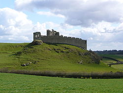 Roche CastleCastle · 3.8 mi
Explorer Tom Roche Castle has caught my eye in County Louth. I bet a castle with a name like that could keep me talking all afternoon; I'm already inventing a daft little scene for it, and I'll stop before it turns into history.
 Mullaghbane MountainMountain / peak · 4.6 mi
Explorer Tom The Glendesha Road leads you right up to Mullaghbane Mountain, so let's follow it and see what this peak has in store.
More castles and forts in County Armagh · All of County Armagh

What do you know about this place?Tap to add a comment or ask a question