What is recorded here
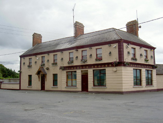
Ginnety's in Dromiskin turns from ‘Grocery’ to ‘Wine and Spirit Store’ as you round the corner. A beautifully short journey from ‘We're out of bread’ to ‘You'll never guess who I met.’
Corner-sited three-bay two-storey house, built c. 1870, now also in use as public house and shop. L-plan, two-bay return to west with single-storey range extending further west, three-bay dwelling to south. Pitched and hipped slate roof, clay ridge tiles, red brick chimneystacks with yellow brick strings and corbels, moulded cast-iron gutters on corbelled eaves, square-profile cast-iron downpipes. Painted roughcast rendered walling, painted smooth rendered straight channelled quoins, smooth rendered projecting plinth. Painted smooth rendered channel-jointed rustication to pubfront, painted moulded render fascia with raised lettering reading "Ginnety's Grocery" turning corner "Wine and Spirit Store". Square-headed window openings, painted smooth rendered slightly projecting reveals, unpainted granite sills, one-over-one painted timber sliding sash windows, square-headed openings to shopfront with painted timber display windows. Square-headed door opening to south, painted smooth rendered slightly-projecting reveals, timber panelled door, plain-glazed overlight, gable-fronted timber bracketed canopy with finial. Square-headed door opening to pub, timber panelled door, plain glazed overlight. Two-storey pitched slate roof outbuilding to rear with single-storey lean-to section to south, roughcast rendered walls, garden to south, bounded by painted roughcast rendered walling with painted smooth rendered copings and plinth course, painted smooth rendered gate piers containing metal gate.
Ginnety's is a handsome and well maintained example of a traditional Irish building type - the combined public house/grocery and private home. It occupies a dominating position at the crossroads of the village and, with the survival of some elements of its fine shopfront and etched window signs, it is a notable local landmark.
From the Buildings of Ireland (National Inventory of Architectural Heritage) record 13829003
This does not grant access. Most recorded buildings are privately owned; view them only from public ground unless the owner allows entry.
Places near here
Viking BoatHeritage attraction · 66 yd Round tower in DromiskinRound tower · 144 ydSaint Ronan's Church (Dromiskin)Church/chapel · 155 ydGraveyard178 ydCh (in Rns)Church · 189 ydDrummeenagh HillMountain / peak · 1.2 miCastleCastle, tower house · 1.3 miLong WoodForest · 2.0 miDunmahon CastleCastle, tower house · 2.6 miGraveyard in Richardstown (ardee By., Richardstown Par.)Graveyard · 5.2 miMonterey Cypress5.2 miGraveyard in StickillinGraveyard · 6.2 mi
 Round tower in DromiskinRound tower · 144 yd
 Saint Ronan's Church (Dromiskin)Church/chapel · 155 yd
 Graveyard178 yd
 Ch (in Rns)Church · 189 ydDrummeenagh HillMountain / peak · 1.2 mi
 CastleCastle, tower house · 1.3 miLong WoodForest · 2.0 mi
 Dunmahon CastleCastle, tower house · 2.6 mi
 Graveyard in Richardstown (ardee By., Richardstown Par.)Graveyard · 5.2 mi
 Monterey Cypress5.2 mi
 Graveyard in StickillinGraveyard · 6.2 mi
Pictures: Kieran Campbell, Wikimedia Commons · CC BY-SA 2.0; DAYVEHUSE, Wikimedia Commons · CC BY-SA 4.0; Darrin Antrobus, Geograph · Creative Commons Attribution-ShareAlike 2.0; Garry Dickinson, Wikimedia Commons · CC BY-SA 2.0; Eric Jones, Geograph · CC BY-SA 2.0; Kieran Campbell, Geograph · Creative Commons Attribution-ShareAlike 2.0; Vadim Manuylov, Wikimedia Commons · CC BY-SA 3.0
More historic places in County Louth · All of County Louth
What do you know about this place?