
What is recorded here
From the National Monuments Service (Archaeological Survey of Ireland) record CO029-035
Places near here
Photo credits
- National Inventory of Architectural Heritage
- Colin Park, Geograph · CC BY-SA 2.0
- Jonathan Thacker, Geograph · CC BY-SA 2.0
- Eeno11, Wikimedia Commons · CC BY-SA 3.0
- User Coil00 on en.wikipedia, Wikimedia Commons · CC BY-SA 3.0
- Ceoil at English Wikipedia, Wikimedia Commons · CC BY-SA 3.0
- Mike Searle, Wikimedia Commons · CC BY-SA 2.0
- EecherplazGinkgo06.jpg : Cayambe derivative work: Ginkgotree ( talk ), Wikimedia Commons · CC BY-SA 3.0
- Marathon, Geograph · CC BY-SA 2.0
- Gareth James, Wikimedia Commons · CC BY-SA 2.0
 Nohoval BridgeBridge · 1494 yd
Explorer Tom Nohoval Bridge is solid rubble with cut-stone voussoirs that probably cost a fortune back in the day. It’s a testament to craftsmanship and has been repaired so many times it knows every local’s secrets. Wave your hand and hope for luck!
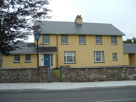 Knocknagree Garda StationGarda station/constabulary barracks · 1.2 mi
Explorer Tom 17. Knocknagree Garda Station looks like a fancy country house because it was built in the Domestic Revival style, which means it hates mass production. Its name really means 'The Place Where You Park Your Car'. Twist your luck and knock on the door!
 Caherbarnagh nw TopMountain / peak · 4.9 mi
 Claragh MountainMountain / peak · 6.0 mi
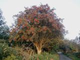 Rowan7.0 mi
Explorer Tom Rowan in County Cork bragged about surviving a storm that was actually just a strong breeze and a lot of wind noise. But hey, confidence is key. Take the long way round, because it deserves the effort.
 Kilmeedy CastleCastle, tower house · 7.3 mi
Explorer Tom Kilmeedy Castle has had its fancy bits stolen by a grumpy farmer who thought he was helping out. It’s a five-storey tower that lost its windows in a fit of pique. Go in good boots and better humour, trust me.
 Glantane EastArchaeological place · 9.7 mi
Explorer Tom Glantane East in County Cork has a wedge tomb hiding out there. It’s from the Bronze Age, so it’s ancient! Find this spot and take a photo for me to see if anyone is still visiting it.
 KnocknakillaArchaeological place · 10 mi
Explorer Tom Knocknakilla is a megalithic complex between Macroom and Millstreet that looks like it’s been there forever. It’s got a very serious vibe about it. Don’t let it scare you, just be friendly.
 Kilmurry CastleCastle · 11 mi
 Ginkgo14 mi
Explorer Tom This Ginkgo in County Kerry thinks Dublin tourists are loud and wear too many hats. It’s been around longer than their excuses for being late. Sit on a wall near it and pretend you're in a painting.
 Monsignor Hugh O'Flaherty MemorialMemorial · 14 mi
 Muckross AbbeyVisitor attraction · 14 mi
More archaeology and monuments in County Cork · All of County Cork

What do you know about this place?Tap to add a comment or ask a question