
What is recorded here
From the National Monuments Service (Archaeological Survey of Ireland) record CO060-086001
Places near here
Photo credits
- Maker not stated on source page, mademoiselleruta.com
- Maker not stated on source page, it.pinterest.com
- Maker not stated on source page, www.pinterest.com
- National Inventory of Architectural Heritage
- Sole Origami, Wikimedia Commons · CC BY-SA 4.0
- Maker not stated on source page, br.pinterest.com
- Jonathan Thacker, Wikimedia Commons · CC BY-SA 2.0
 Church (in Ruins)Church · 607 yd
Explorer Tom Church in Knockrour is basically a rectangular mound with a grassy attitude. The Vikings definitely got lost looking…
 Fairy fort / earthen ringfort in Curraghawaddra (muskerry East By.)Fairy fort / earthen ringfort · 1037 yd
Explorer Tom Fairy fort / earthen ringfort in Curraghawaddra is hiding under conifer trees and a man-made tunnel. A 1997 inventory…
Fairy fort / earthen ringfort in CoolgarriffFairy fort / earthen ringfort · 1193 ydExplorer Tom Fairy fort / earthern ringfort in Coolgarriff got cut in half by a laneway, which is just rude. Half the rampart…
 Anomalous stone group in CoolgarriffAnomalous stone group · 1.1 mi
Explorer Tom Anomalous stone group in Coolgarriff was three stones forming a triangle, one standing upright at the apex. Now there’s…
Church (Site of)Church · 1.5 miExplorer Tom Church in Leadawillin is in a field named Chapel Field, next to a rock outcrop called Donnell's little rock. The site…
 St Eolan's Roman Catholic ChurchChurch/chapel · 1.7 mi
Explorer Tom St Eolan's Roman Catholic Church in Rylane, County Cork broke the mold after Vatican II with its light design. I bet it…
 St John the Baptist ChurchOfficially recorded historic building · 1.7 mi
Explorer Tom St John the Baptist Church was nearly sold for a horse because someone thought the pinnacles were decorative horse…
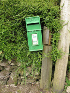 post box1.8 mi
Explorer Tom Post box in Inchaleagh is a little cast-iron guy from 1950 standing opposite the church. It’s got Celtic Revival…
 Leades HouseCountry house · 2.3 mi
Explorer Tom Leades House is a small country house with big dreams and tall windows. The symmetrical chimneys are doing their best…
Fairy fort / earthen ringfort in CarrigthomasFairy fort / earthen ringfort · 3.6 miExplorer Tom Fairy fort / earthen ringfort in Carrigthomas is all talk and no show, with no visible trace left on the surface. Mr.…
 Fairy fort / earthen ringfort in CarrigagullaFairy fort / earthen ringfort · 3.6 mi
Explorer Tom Fairy fort in Carrigagulla is huge, nearly forty-two metres across. It overlooks the Laney River valley. The bank has…
 MusheraMountain / peak · 6.4 mi
Explorer Tom Mushera claims to be older than the concept of time itself, which is a stretch even for a mountain. I say it’s just old…
More archaeology and monuments in County Cork · All of County Cork

What do you know about this place?Tap to add a comment or ask a question