
Places near here
Photo credits
- Sole Origami, Wikimedia Commons · CC BY-SA 4.0
- Jim Woodward-Nutt, Wikimedia Commons · CC BY-SA 2.0
- Joebater at English Wikipedia, Wikimedia Commons · CC BY-SA 3.0
- Donald MacDonald, Geograph · CC BY-SA 2.0
- Maker named on the Wikimedia Commons picture page · CC BY-SA 2.5
- Jo and Steve Turner, Geograph · CC BY-SA 2.0
- Ceoil at English Wikipedia, Wikimedia Commons · CC BY-SA 3.0
- me, Wikimedia Commons · Public domain
- Jonathan Thacker, Wikimedia Commons · CC BY-SA 2.0
 Hanover Hall BridgeBridge · 1271 yd
Explorer Tom Hanover Hall Bridge is designed with the precision of a very strict mother-in-law. Every cut stone is placed exactly where it belongs, no wiggling allowed. Admire the craftsmanship and maybe whisper how lucky you are to see it.
 St John the Baptist Roman Catholic ChurchChurch/chapel · 1551 yd
Explorer Tom St John the Baptist Roman Catholic Church in Kilberrihert is keeping it simple and barn-like. Built around 1800, it’s got those pointed arch windows that look like they’re about to sing. It’s pre-Emancipation, so it’s got history. Take a snap of the gallery!
 Bealick MillVisitor attraction · 2.3 mi
Explorer Tom Bealick Mill would teach history like a strict teacher who only uses one-liners and expects you to already know the answers. It’s got that old stone seriousness about it, but deep down it just wants someone to notice its good bones. Count the crows, then count again.
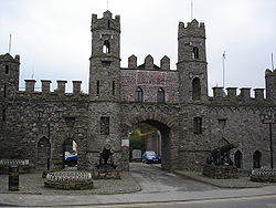 Battle of MacroomBattle · 2.6 mi
Explorer Tom The Battle of Macroom is constantly trying to one-up its more famous cousin next door by claiming it had better weather and a superior supply of biscuits, which is why the soldiers fought with such enthusiasm and zero dignity. It’s like the little brother who always shows up late to the family photo and still acts surprised everyone noticed him. If it’s closed, admire it from the road like a polym
 Macroom Castle (in Ruins)Castle, tower house · 2.7 mi
Explorer Tom Macroom Castle got demolished in 1967 to build a technical school, which is either genius or terrible. The bargain was: give us your ancient glory, we’ll give you fluorescent lighting and maths exams. It’s the only castle that died for education, bless it. Bring sandwiches, the gulls will thank you.
 Sessile Oak3.9 mi
Explorer Tom Sessile Oak in County Cork would post on social media: 'Another day, another leaf falling. #NatureIsIndifferent.' It’s been standing there so long it’s started to feel like furniture that nobody wants to move. The bark is thick enough to hide a secret or two. Ring your granny and tell her where you are.
 Carrigadrohid CastleHeritage attraction · 3.9 mi
Explorer Tom Carrigadrohid Castle in County Cork is playing hard to get, like it’s waiting for a really good deal on its own walls. Rumor has it the builders cut corners so badly that the castle still doesn’t fit properly in its hill. Find a local and ask them the real story, then come back and tell me.
 Carrigadrohid Castle (in Ruins)Castle, tower house · 3.9 mi
Explorer Tom Carrigadrohid Castle is standing in water because someone decided to build a dam nearby. It's basically an island now, which is very dramatic. The MacCarthys built this back in the fifteenth century, so it's seen some stuff!
 Carrigagulla Stone CircleArchaeological place · 4.4 mi
Explorer Tom Carrigagulla Stone Circle in County Cork is north of Ballinagree and looks like it’s waiting for someone to start dancing. I bet they used to party hard here. Check if the circle is complete or if one stone ran off.
 The Gearagh Nature ReserveNature reserve · 5.0 mi
Explorer Tom The Gearagh Nature Reserve remembers the time a priest lost a bet there and had to wear a penguin suit for a week, which was undignified. The reeds are still giggling about it. Take a mate and argue about what it was for.
 MusheraMountain / peak · 5.9 mi
Explorer Tom Mushera claims to be older than the concept of time itself, which is a stretch even for a mountain. I say it’s just old enough to complain about its knees. Bring curiosity, leave with a better story than mine.
 KnocknakillaArchaeological place · 6.4 mi
Explorer Tom Knocknakilla in County Cork would spend its lotto win on buying more stones to add to its circle. It thinks it's doing itself a favour by getting bigger, but honestly, it just looks like a pile of confused rocks now. Tell the next person you meet it's haunted. It might be.
More archaeology and monuments in County Cork · All of County Cork

What do you know about this place?Tap to add a comment or ask a question