
Places near here
Photo credits
- National Inventory of Architectural Heritage
- Corkonian2013, Wikimedia Commons · CC BY-SA 3.0
- Frederick Dean, Geograph · CC BY-SA 2.0
- Hywel Williams, Wikimedia Commons · CC BY-SA 2.0
- Mike Searle, Wikimedia Commons · CC BY-SA 2.0
- Sole Origami, Wikimedia Commons · CC BY-SA 4.0
- Jo and Steve Turner, Geograph · CC BY-SA 2.0
- David P Howard, Geograph · CC BY-SA 2.0
- Jonathan Thacker, Geograph · Creative Commons Attribution-ShareAlike 2.0
- Jonathan Thacker, Wikimedia Commons · CC BY-SA 2.0
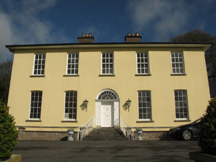 Aghavrin HouseHouse · 458 yd
Explorer Tom Aghavrin House is so symmetrical it makes me dizzy, with chimneystacks that look like they're trying to punch the sky. If it talked to its younger self, it would say 'stop slouching, we have grandeur to maintain.' Get in there and bow.
 Dromatimore HouseHouse · 1421 yd
Explorer Tom Dromatimore House had a prophecy that it would become a castle, but instead it just became a very fancy cross-shaped house. It’s got bowed breakfronts that make it look like it’s about to hug the world. Wave at its cruciform plan from the short drive if you dare.
 Mullinhassig WoodWood · 1.1 mi
Explorer Tom Mullinhassig Wood clearly got left in the wrong bin by some careless cartographer. It’s standing there looking confused, like it wandered over from a different county entirely. Have a sandwich here and call it a heritage lunch if you dare.
 Mullinhassig WaterfallWaterfall · 1.1 mi
Explorer Tom Mullinhassig Waterfall is feuding with the next village over something daft like who has the best mud on their shoes this season. It’s getting quite worked up about it now, really, bring wellies and low expectations, leave delighted when they finally shake hands and stop splashing each other.
.jpg/250px-St._Olan's_Well_-_geograph.org.uk_-_2832674_(cropped).jpg "Photo: Hywel Williams, Wikimedia Commons · CC BY-SA 2.0") St Olans WellHoly well · 1.8 mi
St Olans WellHoly well · 1.8 miExplorer Tom St Olans Well is surrounded by stone and votive offerings, making it look a bit like an ancient jewelry box. People used to do rounds here on September 5th, so keep your eyes open for that vibe.
 Carrignamuck Tower HouseCastle · 2.3 mi
Explorer Tom Carrignamuck Tower House in County Cork is standing in the grounds of Dripsey Castle, looking slightly out of place. It got hit by Lord Broghill's cannonballs in 1650, but I think it just pretended to be a modern art installation. Now it looks like something you'd find in a very confusing dream. Bring a flask of something warm and a story to swap.
Carrigadrohid Castle InfoVisitor information · 2.6 miExplorer Tom Carrigadrohid Castle Info has a fairy dispute over parking rights that has been ongoing since the medieval era, and nobody is winning. The castle itself probably just wants you to admire its rocks without asking too many difficult questions. Pick a stone, any stone, and invent its biography.
 Carrigadrohid CastleHeritage attraction · 2.7 mi
Explorer Tom Carrigadrohid Castle in County Cork is playing hard to get, like it’s waiting for a really good deal on its own walls. Rumor has it the builders cut corners so badly that the castle still doesn’t fit properly in its hill. Find a local and ask them the real story, then come back and tell me.
 Carrigadrohid Castle (in Ruins)Castle, tower house · 2.7 mi
Explorer Tom Carrigadrohid Castle is standing in water because someone decided to build a dam nearby. It's basically an island now, which is very dramatic. The MacCarthys built this back in the fifteenth century, so it's seen some stuff!
 Farran WoodWood · 3.5 mi
Explorer Tom Farran Wood in County Cork is where that one stubborn cow tried to buy the whole lot with a single coin and walked away looking smug. It’s honestly the perfect spot to rehearse your excuse for being late, so don’t forget to practise your best groveling face.
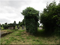 Grave YardGraveyard · 3.7 mi
Explorer Tom Graveyard in Aglish sits on a ridge, watching the Lee valley while pretending it isn’t also a church ruin. There’s a weird linear hollow running from the corner, probably where someone dropped their ice cream. Bring your own legend, I've run out.
 Kilcrea FriaryGraveyard · 6.1 mi
Explorer Tom Kilcrea Friary in County Cork looks like it’s been losing a long argument with the local breeze for centuries. The walls are leaning over like they’re checking their phones. Best seen with a hangover and a sausage roll.
More archaeology and monuments in County Cork · All of County Cork

What do you know about this place?Tap to add a comment or ask a question