
What is recorded here
From the National Monuments Service (Archaeological Survey of Ireland) record CO061-054
Places near here
Photo credits
- National Inventory of Architectural Heritage
- Jonathan Thacker, Geograph · CC BY-SA 2.0
- Mike Searle, Wikimedia Commons · CC BY-SA 2.0
- Hywel Williams, Wikimedia Commons · CC BY-SA 2.0
- Corkonian2013, Wikimedia Commons · CC BY-SA 3.0
- Frederick Dean, Geograph · CC BY-SA 2.0
- David P Howard, Geograph · CC BY-SA 2.0
Explorer Tom Man-made underground passage in Derry is blocked up and collapsed inside the ringfort. Hartnett saw some flagstones in 1937, but now it’s just a mystery hole. Grab a pic for me if you see any exposed roof stones!
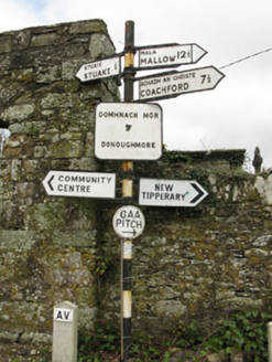 sign post1.8 mi
Explorer Tom Sign post in Lackabane is showing off its new harp haircut. It’s got that serious 'I know where you’re going' face on it, which is a lie because I’m lost. Bring a notebook to write down how smug it looks!
 farm house1.8 mi
Explorer Tom Farm house in Lackabane is modest and unadorned, which makes it secretly the coolest one on the block. It probably thinks the road leading to it is a bit of a mess. Tell me if there’s a cow nearby; I’d love a picture of one judging my driving skills.
 New TipperaryVisitor information · 2.3 miSaint Bartholomew's WellSpring · 2.3 miBallyvodane Castle (in Ruins)Castle, unclassified · 2.6 mi
Explorer Tom Ballyvodane Castle is fragmentary remains in a pasture, much of it bulldozed some years ago. Part of the north wall survives with a base batter. No trace of the south or west walls. It looks like a castle that got hit by a very small, very angry tractor.
 Carrignamuck Tower HouseCastle · 2.6 mi
Explorer Tom Carrignamuck Tower House in County Cork was breached by Lord Broghill in 1650. It's now in Dripsey Castle's grounds. Take a photo for me if you can find the hole in the east wall!
 St Olans WellHoly well · 3.4 mi
Explorer Tom St Olans Well is surrounded by stone and votive offerings, making it look a bit like an ancient jewelry box. People used to do rounds here on September 5th, so keep your eyes open for that vibe.
Ballyanly Inniscarra Slí na SláinteWalking route · 3.6 mi Mullinhassig WoodWood · 4.9 mi
 Mullinhassig WaterfallWaterfall · 4.9 mi
 Farran WoodWood · 5.0 mi
More archaeology and monuments in County Cork · All of County Cork

What do you know about this place?Tap to add a comment or ask a question