
What is recorded here
From the National Monuments Service (Archaeological Survey of Ireland) record CO045-120001
Places near here
Photo credits
- Jonathan Thacker, Wikimedia Commons · CC BY-SA 2.0
- Maker not stated on source page, www.gpsmycity.com
- Maker not stated on source page, www.dreamstime.com
- Mike Searle, Wikimedia Commons · CC BY-SA 2.0
- Mike Searle, Geograph · CC BY-SA 2.0
- Jonathan Thacker, Geograph · CC BY-SA 2.0
- Maker not stated on source page, www.pinterest.com
- National Inventory of Architectural Heritage
- Maker not stated on source page, fi.pinterest.com
- Maker not stated on source page, www.tripadvisor.com
 Saint James' ChurchChurch/chapel · 19 yd
Explorer Tom Saint James' Church in Aghern East has sandstone pinnacles that point at the sky like it’s accusing God of something.…
 Church in Aghern EastChurch · 23 yd
Explorer Tom Church in Aghern East built on ancient ground but looks like a fancy brick box from 1816. It’s got a tower that screams…
 Aghern GraveyardGraveyard · 23 yd
Explorer Tom Aghern Graveyard’s name actually means 'The Place Where We Forgot To Plant The Potatoes' according to my very reliable…
 Aghern BridgeBridge · 121 yd
Explorer Tom Aghern Bridge is built by skilled craftsmen who clearly thought rubble limestone was just too easy for them. The…
 Country house in Aghern WestCountry house · 269 yd
Explorer Tom Country house in Aghern West was built after a bargain where a man traded his horse for a view of the river. The bow on…
 Aghern HouseCountry house · 270 yd
Explorer Tom "Aghern House is playing it cool with its Georgian bows and serious slate roof. It would survive a reality show by just…
 Aghern CastleCastle · 287 yd
Explorer Tom Aghern Castle in County Cork is paired with a house from about 1740 that looks far too fancy. The castle itself dates…
 Castle (in Ruins)Castle, unclassified · 302 yd
Explorer Tom Castle in Aghern West is attached to a house and coachyard, which is a weird combo. It used to be two towers connected…
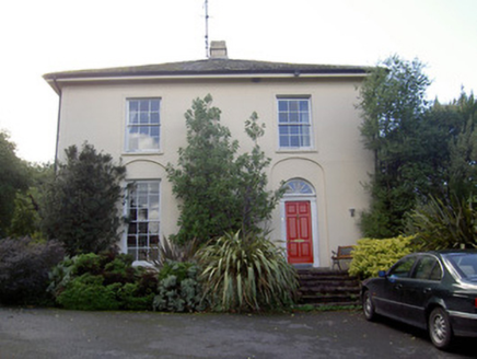 Brideweir HouseRectory/glebe/vicarage/curate's house · 452 yd
Explorer Tom Brideweir House in Knocknagapple would post 'Me and my acorn finials' on social media, but it’s too shy to show its…
 Old Railway ViaductViewpoint · 5.9 mi
Explorer Tom Old Railway Viaduct has a retirement plan that involves becoming a very expensive bird feeder. It’s got iron girders…
 Licklash Castle (in Ruins)Fortification · 6.1 mi
Explorer Tom Licklash Castle is actually referred to as a hall-house, so calling it a castle is like calling a sandwich a pizza. It…
 Fairy fort / earthen ringfort in Rath-HealyFairy fort / earthen ringfort · 6.2 mi
Explorer Tom Fairy fort / earthen ringfort in Rath-Healy was built by an Ulster chieftain's parents. No trace remains now, according…
More archaeology and monuments in County Cork · All of County Cork

What do you know about this place?Tap to add a comment or ask a question