What is recorded here
From OpenStreetMap (© OpenStreetMap contributors) w1374823186
Places near here
Picture notes
- Jonathan Thacker, Wikimedia Commons · CC BY-SA 2.0
- Computer-made picture. It does not show this monument.
- Mike Searle, Wikimedia Commons · CC BY-SA 2.0
- Mike Searle, Geograph · CC BY-SA 2.0
- Jonathan Thacker, Geograph · CC BY-SA 2.0
- National Inventory of Architectural Heritage
- Revd. Matthew Morgan, Wikimedia Commons · Public domain
 Saint James' ChurchChurch/chapel · 9 yd
Explorer Tom Saint James' Church in Aghern East has sandstone pinnacles that point at the sky like it’s accusing God of something. It’s a Board of First Fruit type church, which sounds like a club you don't belong to. Look up!
 G YdGraveyard · 23 ydComputer-made picture. It does not show this monument.
Explorer Tom Graveyard in Aghern East is rectangular and has headstones from the 1760s, which are definitely getting on a bit now. It's right by the river Bride bridge, so the water might try to claim something new soon.
 Aghern BridgeBridge · 140 yd
Explorer Tom Aghern Bridge is built by skilled craftsmen who clearly thought rubble limestone was just too easy for them. The U-shaped cutwaters are flexing their engineering muscles right now. If it rains, tell me if the water goes over or under.
 Country house in Aghern WestCountry house · 276 yd
Explorer Tom Country house in Aghern West has a bow that’s seen better days, and a local swears he invented the concept of having a front door. Ideal spot for a dramatic phone call.
 Aghern HouseCountry house · 277 yd
Explorer Tom Aghern House in Aghern West has a bow-shaped front and slate hanging. I think 'Aghern' is local slang for 'aggressive heron'. Go on, check if the canted bay is hiding any secret bird nests.
 Aghern CastleCastle · 295 yd
Explorer Tom Aghern Castle in County Cork is paired with a house from about 1740 that looks far too fancy. The castle itself dates back to 1389. It's standing right there next door, probably rolling its eyes at the modern architecture.
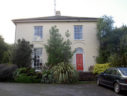 Brideweir HouseRectory/glebe/vicarage/curate's house · 469 yd
Explorer Tom Brideweir House has its front on the side, which makes me think the architect was lost in Knocknagapple. It’s got acorn finials that look like they’re judging your outfit. Bring your own
 Fairy fort / earthen ringfort in KnocknagappleFairy fort / earthen ringfort · 610 ydComputer-made picture. It does not show this monument.
Explorer Tom Fairy fort / earthen ringfort in Knocknagapple is levelled but the fences still curve around it out of respect. It’s like the land remembers its shape even if the bank doesn't. Tell the kids it's a castle. Close enough, they won't check the survey maps.
 IndicatedFairy fort / earthen ringfort · 867 ydComputer-made picture. It does not show this monument.
Explorer Tom Fairy fort or earthen ringfort in Knocknagapple is at the junction of four fields. Only the lower part of the original bank survives to the east, replaced by stone walls elsewhere. It’s planted with trees and used for feeding cattle. Take a pic of the cows!
 Fairy fort / earthen ringfort in Kilclare UpperFairy fort / earthen ringfort · 978 ydComputer-made picture. It does not show this monument.
Explorer Tom Fairy fort / earthen ringfort in Kilclare Upper is hiding behind the trees like a shy introvert. There’s even an underground tunnel, probably for secret fairy parties. Ideal for a moody photo you'll pretend wasn't posed.
 Rathcormac massacreMassacre · 5.5 mi
Explorer Tom The Rathcormac Massacre of 1834 saw farmers hiding behind haystacks like it was a game of hide-and-seek with soldiers. A bit dramatic, but hey, history loves a good scare. Go with someone who loves old stuff and watch them melt.
 Old Railway ViaductViewpoint · 5.9 mi
Explorer Tom Old Railway Viaduct has caught my eye in County Cork. I bet a viewpoint with a name like that could keep me talking all afternoon; I'm already inventing a daft little scene for it, and I'll stop before it turns into history.
More memorials and graveyards in County Cork · All of County Cork

What do you know about this place?Tap to add a comment or ask a question