What is recorded here
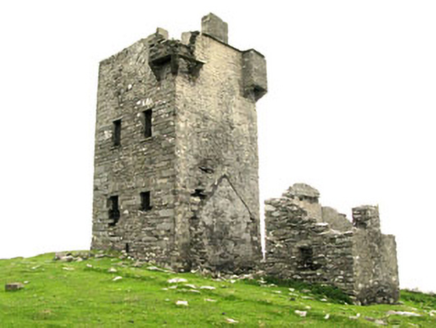
On grassy island just separated from SE corner of Dursey Island by narrow gorge; sod-covered remains of two rectangular buildings within a rectangular enclosure (23m N-S; 31.3m E-W). Garrisoned by O'Sullivan Beare in 1602 but taken by Carew before the fall of Dunboy (Healy 1988, 196).
From the National Monuments Service (Archaeological Survey of Ireland) record CO126-012001
The monument record does not grant public access. Check the route and ask the landowner before entering private land.
- What survives
- Recorded monument
Places near here
Photo credits
- Mat Tuck, Geograph · CC BY-SA 2.0
- Hywel Williams, Geograph · CC BY-SA 2.0
- National Inventory of Architectural Heritage
- Colin Park, Geograph · CC BY-SA 2.0
- John M, Wikimedia Commons · CC BY-SA 2.0
- Benson Wills, Wikimedia Commons · CC BY-SA 2.0
- colm, Geograph · CC BY-SA 2.0
- Julian Paren, Geograph · CC BY-SA 2.0
- John M, Geograph · CC BY-SA 2.0
- Richard Webb, Geograph · CC BY-SA 2.0
 Dursey IslandVisitor information · 598 yd
 Dursey Cable CarHeritage attraction · 794 yd
 Dursey Island National SchoolSchool · 1.1 mi
 Little IslandIslet · 1.6 mi
 Dursey Watch TowerSignal tower · 2.0 mi
 Cnoc BólaisMountain / peak · 2.0 mi
 Promontory fortPromontory fort, coastal · 2.7 mi
 Wedge tomb in Killough EastWedge tomb · 4.1 mi
 The CalfIslet · 4.4 mi
 Ballydonegan StrandBeach / strand · 4.8 mi
 DooneenViewpoint · 5.5 mi
 Eagle HillMountain / peak · 5.6 mi
More castles and forts in County Cork · All of County Cork
What do you know about this place?