What is recorded here
No trace of the 'Park Fort' of the OS 6-inch maps now survives. Previous reports indicate that its internal diameter was about 50ft. It was situated in good rolling farmland. (O. Davies). The above description was derived from the 'Archaeological Survey of County Donegal. A description of the field antiquities of the…
Read the whole record
From the National Monuments Service (Archaeological Survey of Ireland) record DG107-017
Places near here
Photo credits
- Maker not stated on source page, www.flickr.com
- National Inventory of Architectural Heritage
- Maker not stated on source page, www.pinterest.com
- louise price, Wikimedia Commons · CC BY-SA 2.0
- Maker not stated on source page, waterfordwhispersnews.com
- Maker not stated on source page, irishheritagenews.ie
- Maker not stated on source page, irelandsholywells.blogspot.com
- Maker not stated on source page, commons.wikimedia.org
- Kay Atherton, Geograph · CC BY-SA 2.0
- louise price, Wikimedia Commons
 Giant's Grave Wedge TombWedge tomb · 412 yd
Explorer Tom Giant's Grave Wedge Tomb had a six-metre gallery, partly hidden by later fill, and well-preserved outer stonework in…
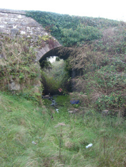 bridge463 yd
Explorer Tom Bridge in Kilbarron puts raised render around its arch like a grin. Built around 1905 for the narrow gauge railway…
 Kilbarron Old ChurchChurch · 720 yd
Explorer Tom Kilbarron Old Church has five pairs of joist holes that the survey read as marks of a former gallery. A gallery without…
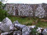 Kilbarron Old Church GraveyardGraveyard · 734 yd
Explorer Tom Kilbarron Old Church Graveyard features a 15th or 16th century ruin with a 2.4m high E gable that has no window at all.…
 Childrens Burial GroundChildren's burial ground · 740 yd
Explorer Tom Childrens Burial Ground in Kilbarron has an imaginary fan club that meets every Tuesday night to discuss the best songs…
 An Chlochbhuaile Earthen RingfortFairy fort / earthen ringfort · 914 yd
Explorer Tom An Chlochbhuaile Earthen Ringfort is barely even a ring anymore, more like a vague suggestion of a circle in some wet…
 Holy well in KilbarronHoly well · 951 yd
Explorer Tom In Kilbarron, Ó Muirgheasa placed St Barron's well near the railway in his 1936 account. A later record called it a…
 Dark Cliffs at KilbarronPublicly named cliff or headland · 1248 yd
Explorer Tom Dark Cliffs at Kilbarron would absolutely complain to the council about tourists not knowing their place, and honestly…
 Kilbarron Castle in ruinsCastle, tower house · 1402 yd
Explorer Tom Kilbarron Castle in ruins clings to a precipitous promontory, where the O'Clerys rebuilt their stronghold after 1390. I…
 CastleCastle, unclassified · 1409 yd
Explorer Tom Castle! Donnell O’Conor demolished this specific castle, but wait, this record is about an older one than what you see…
 Creevy Pier HotelHotel · 1541 yd
Explorer Tom Creevy Pier Hotel suggests you're staying on a pier that might wobble dangerously in high tide, with the 'hotel' part…
 Creevy Coastal WalkOfficial walking route · 1566 yd
Explorer Tom Creevy Coastal Walk begins at a pier and soon puts Donegal Bay on magnificent display, with a clifftop path that…
More archaeology and monuments in County Donegal · All of County Donegal

What do you know about this place?Tap to add a comment or ask a question