What is recorded here
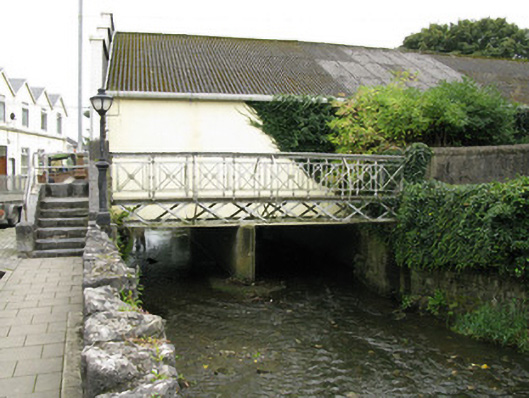
Foot bridge in Gortboy owes its iron crossing to the cost of building in brick and stone. It leads towards Saint Mary’s, which is handy: you could cross yourself for nothing, but getting yourself across the Arra took a cheaper quote.
Freestanding single-span cast- and wrought-iron footbridge, dated 1866, spanning the River Arra. Cross-braced truss construction springing from tooled limestone piers having flanking square-profile tooled limestone pillars to north and south and termini. Cast-iron panelled decking to bridge. Decorative cast-iron railing to parapet having bowed bracing rails to east and west. Tooled limestone stepped approach to northern bank flanked by tooled limestone parapet walls having coping and piers with later galvanised-steel handrail. Tooled limestone plaque to side (north) elevation of stepped approach. Recent tarmac paved approach to southern bank flanked by rendered enclosing walls having render coping and rendered stepped approach with recent galvanised-steel railing. Dressed rubble stone-faced embankments to north and south banks of river.
Erected by Edward Curling, the landlord's agent in Newcastle West (1818-1874), this bridge forms a delightful architectural feature over the River Arra. The large cost in materials and construction of brick and masonry led to a search for alternatives resulting in the use of cast-iron. Prefabrication techniques using cast-iron were still developing during this period hence the use of a relatively simple braced truss system to create a rigid base. The bridge is further enhanced by the use of high quality tooled limestone in its piers and which complement the elegant form of this fine bridge. The bridge provides an important bridging point over the River Arra linking the southern area of town with Saint Mary's Roman Catholic Church and the central business area of Newcastle West.
From the Buildings of Ireland (National Inventory of Architectural Heritage) record 21837040
This does not grant access. Most recorded buildings are privately owned; view them only from public ground unless the owner allows entry.
Places near here
Photo credits
- National Inventory of Architectural Heritage
- Ian S, Geograph · Creative Commons Attribution-ShareAlike 2.0
- Mike Searle, Wikimedia Commons · CC BY-SA 2.0
- Garry Dickinson, Geograph · CC BY-SA 2.0
- Created by Kglavin Modified Aug 2007 by Mike Christie, Wikimedia Commons · CC BY-SA 3.0
- A.-K. D., Wikimedia Commons · CC BY-SA 4.0
- Willow, Wikimedia Commons · CC BY 2.5
- jonleebotany, Wikimedia Commons · CC0
 monument63 yd
 Catholic Church of the Immaculate ConceptionChurch/chapel · 88 yd
,_Newcastle_West,_Limerick_-_geograph.org.uk_-_1392672.jpg/250px-Castles_of_Munster,_Desmond_Hall_(Castle_Banqueting_Hall),_Newcastle_West,_Limerick_-_geograph.org.uk_-_1392672.jpg "Photo: Mike Searle, Wikimedia Commons · CC BY-SA 2.0") Templars Castle (in ruins)Castle, Anglo-Norman masonry castle · 214 ydBurial GroundGraveyard · 1067 yd
Templars Castle (in ruins)Castle, Anglo-Norman masonry castle · 214 ydBurial GroundGraveyard · 1067 yd Castle MahonCastle · 2.8 mi
 Ardagh FortArchaeological place · 3.1 miLimerick GreenwayWalking route · 3.5 miSt. Luke's WellSpring · 4.2 miSugar HillMountain / peak · 4.7 mi
 Saint Ite's WellSpring · 4.7 mi
 European ash4.9 mi
 Lawson's Cypress9.2 mi
More historic places in County Limerick · All of County Limerick
What do you know about this place?