
Places near here
Photo credits
- louise price, Geograph · Creative Commons Attribution-ShareAlike 2.0
- National Inventory of Architectural Heritage
- louise price, Wikimedia Commons · CC BY-SA 2.0
- William Frederick Wakeman (1822-1900), Wikimedia Commons · Public domain
- D Gore, Geograph · CC BY-SA 2.0
- Andreas F. Borchert, Wikimedia Commons · CC BY-SA 4.0
- Andreas F. Borchert, Wikimedia Commons · CC BY-SA 3.0 de
- louise price, Geograph · CC BY-SA 2.0
- Wikimedia Commons contributor shown on the public file page · Public domain
- Kenneth Allen, Geograph · CC BY-SA 2.0
 Aghlem BridgeBridge · 1.9 mi
Explorer Tom Aghlem Bridge carries the road over the Drummenny River on one wide stone arch. The present bridge is dated to about 1860, but an 1837 map shows an earlier crossing here. I picture the old bridge nudging the new stonework: 'You think you're the first one on this spot?'
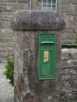 post box1.9 mi
Explorer Tom Post box in Copany is a cast-iron legend with Celtic Revival script. It’s got a P & T motif that looks like it was carved by a wizard. Give it a gentle pat and see if it rings out!
 The Ring, Leghawny Stone EnclosureEnclosure · 2.2 mi
Explorer Tom The Ring, Leghawny Stone Enclosure is soaked through and hides a seat-like stone structure called 'the Chair'. It’s not exactly comfortable, but it’s the perfect spot to watch the rain come down on Clogher Hill in absolute solitude.
Pettigo Plateau Nature ReserveNational nature reserve · 2.5 miExplorer Tom Pettigo Plateau Nature Reserve spreads across bog, lakes and wet heath, with an old trackway and cottage remains from two families who lived here in the mid-1800s. The landscape keeps its human history in plain sight.
 Saints IslandIsland · 4.2 mi
Explorer Tom Saints Island sounds like the place to land for the Lough Derg pilgrimage, but that is Station Island next door. This island held the early monastery; Lough Derg calls it overgrown and inaccessible. Even my map needs the two islands kept straight.
 Harvey's PointRestaurant · 4.6 mi
Explorer Tom Harvey's Point was built by a Swiss family who probably got lost pointing in the wrong direction originally. The manicured lawns run right down to the water’s edge looking very official. Ring your granny and tell her where you are.
 St Patrick's CrossCross · 4.9 mi
Explorer Tom St Patrick's Cross on Station Island is a 1.3m shaft wrapped in spiralling bands that look like ancient rope. It’s said to have been moved here from Saint's Island, which sounds like a bit of a logistical nightmare back then. Standing next to the penal beds, it feels like a tiny, confused survivor of a much bigger monastic operation.
 Station IslandIsland · 4.9 mi
Explorer Tom Station Island is the Lough Derg pilgrimage island; the older monastery island is its neighbour, Saints Island. The traditional pilgrimage lasts three days. I would want the current dates and a proper booking sorted before I packed, because a lake crossing deserves more planning than my usual wandering.
 Benson's HillMountain / peak · 5.0 mi
Explorer Tom Benson's Hill has a tiny glimpse of Lough Eske that makes it feel special and mysterious. I bet it’s hiding something big right next to that little peek of water. Snap one photo, then put the phone away and actually look.
 BarnesmoreMountain / peak · 5.2 mi
Explorer Tom Barnesmore has been carrying the wrong name tag. Mountaineering Ireland calls this summit Croaghonagh and says Barnesmore belongs to the gorge below. I would ask the mountain to swap labels with the road, but it has stood its ground longer than my map has.
 Ard na Mona WoodOfficial walking route · 5.4 mi
Explorer Tom Ard na Mona Wood is an ancient oak woodland that’s seen better days but still rocks. It's a 1.9 km loop, perfect for a quick wander. Bring a coin for luck and keep it in your pocket for good measure.
 Patrick the PilgrimMemorial · 5.4 mi
Explorer Tom Patrick the Pilgrim is a memorial that’s clearly been on a long journey to get here. St. Patrick’s Purgatory is in the background, which suggests this guy had some serious spiritual homework to do. Stand where the owner stood and practise looking smug.
More mountains and hills in County Donegal · All of County Donegal

What do you know about this place?Tap to add a comment or ask a question