
What is recorded here
From the National Monuments Service (Archaeological Survey of Ireland) record RO028-046003
Places near here
Photo credits
- Maker not stated on source page, commons.wikimedia.org
- Eric Jones, Geograph · Creative Commons Attribution-ShareAlike 2.0
- Maker not stated on source page, www.pinterest.com
- Tulsk GAA club website; individual photographer not stated, www.tulskgaa.ie
- Willow, Wikimedia Commons · CC BY 2.5
- Sawyer777, Wikimedia Commons · CC BY-SA 4.0
- Gillaween, Wikimedia Commons · CC BY-SA 4.0
- Maker not stated on source page, www.arrivalguides.com
- National Inventory of Architectural Heritage
- Maker not stated on source page, www.visitgalway.ie
- Mike Searle, Wikimedia Commons · CC BY-SA 2.0
 Kilcooley GraveyardGraveyard · 69 yd
Explorer Tom Kilcooley Graveyard in Roscommon would order a triple portion of chips with mushy peas and absolutely no sauce, because…
 Grave YardGraveyard · 81 yd
Explorer Tom Graveyard in Kilcooley is sitting on a low hill pretending it hasn't been expanded for centuries. The south wall of the…
 Holy well in KilcooleyHoly well · 90 yd
Explorer Tom Holy well in Kilcooley is known as Barrys Well, which sounds like a guy who never paid his rent. Nobody locally knows…
 Tulsk Lord Edwards GAAGAA ground · 1.3 mi
 Church (in Ruins)Church · 2.2 mi
Explorer Tom Church in Carns has a shortcut that isn't a shortcut, leading you through fields to nowhere in particular unless you…
 European ash2.9 mi
Explorer Tom European ash in County Roscommon has been the subject of some wild prophecies that never actually came true, which is…
 Queen Medb: RathcroghanLegend location · 4.6 mi
Explorer Tom Queen Medb: Rathcroghan is where the Táin starts turning a quarrel about a bull into an epic. Medb had a royal seat…
 The Mórrígan: OweynagatLegend location · 4.6 mi
Explorer Tom The Mórrígan: Oweynagat is called the Cave of Cats, which fooled me into expecting a very ordinary sort of trouble.…
 CastleCastle, unclassified · 4.8 mi
Explorer Tom Castle in Ballinderry has a bird living on it that refuses to leave, probably because the rent is free. It stares at…
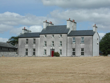 Dundermot HouseCountry house · 11 mi
Explorer Tom Dundermot House in Dundermot sits on a hill overlooking the River Suck, probably humming 'Country Roads' every single…
 Glinsk CastleVisitor attraction · 12 mi
Explorer Tom Glinsk Castle smells like a mix of old books, wet stone, and whatever the ghosts were having for dinner last night…
 Bawn in Glinsk (ballymoe By.)Bawn · 12 mi
Explorer Tom Bawn in Glinsk listens to what goes on inside the walls and probably hears the Burkes arguing about who left the light…
More archaeology and monuments in County Roscommon · All of County Roscommon

What do you know about this place?Tap to add a comment or ask a question