
What is recorded here
From the National Monuments Service (Archaeological Survey of Ireland) record RO021-073002
Places near here
Photo credits
- Maker not stated on source page, www.thejournal.ie
- Maker not stated on source page, www.wikidata.org
- Gillaween, Wikimedia Commons · CC BY-SA 4.0
- Maker not stated on source page, www.flickr.com
- Sawyer777, Wikimedia Commons · CC BY-SA 4.0
- Maker not stated on source page, tr.pinterest.com
- Maker not stated on source page, www.pac.ru
- Maker not stated on source page, irishheritagenews.ie
- National Inventory of Architectural Heritage
- Maker not stated on source page, www.tuatha.ie
- Kmcnamee, Wikimedia Commons · CC BY-SA 4.0
 Fairy fort / earthen ringfort in GortnasillaghFairy fort / earthen ringfort · 743 yd
Explorer Tom Fairy fort / earthen ringfort in Gortnasillagh has completely vanished from the ground but hangs out on old aerial…
 Fairy fort / earthen ringfort in TonroeFairy fort / earthen ringfort · 1.2 mi
Explorer Tom Fairy fort / earthen ringfort in Tonroe is stuck in a feud with the hill next door over who gets to see the sunset…
 The Mórrígan: OweynagatLegend location · 1.6 mi
Explorer Tom The Mórrígan: Oweynagat is called the Cave of Cats, which fooled me into expecting a very ordinary sort of trouble.…
 Stone CrossMemorial stone · 1.8 mi
Explorer Tom Stone Cross in Drishaghaun East gets its opinions from the local sheep, who think it’s just another rock for chewing.…
 Queen Medb: RathcroghanLegend location · 2.0 mi
Explorer Tom Queen Medb: Rathcroghan is where the Táin starts turning a quarrel about a bull into an epic. Medb had a royal seat…
 Church in KillasterChurch · 2.4 mi
Explorer Tom Church in Killaster has nothing to say to the place that replaced it because it never really existed in the first…
 Bridge in KillasterBridge · 2.5 mi
Explorer Tom Bridge in Killaster’s name actually means 'The Place Where You Drop Your Sandwich,' if you ask me. It’s a stone lintel…
 Fairy fort / earthen ringfort in Carrownaskeagh (roscommon By., Ogulla Ed)Fairy fort / earthen ringfort · 2.6 mi
Explorer Tom Carrownaskeagh’s ringfort has a fosse full of reeds that look like they’re trying to grow into a hedge. The shortcut…
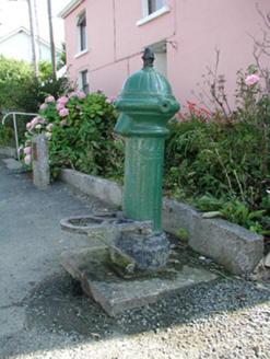 water pump3.4 mi
Explorer Tom The water pump in Bellanagare still works, which is impressive, considering it has had at least three different names…
 Bellanagare CastleCastle, unclassified · 3.5 mi
Explorer Tom Bellanagare Castle would post a selfie with the caption 'Ancient vibes only' and get ten likes. It was an O'Conor home…
 CastleCastle, unclassified · 4.0 mi
Explorer Tom Castle in Bohagh, County Roscommon hears everything through its walls, including the sound of Captain Brabazon losing…
 St. Croans GAAGAA ground · 5.0 mi
More archaeology and monuments in County Roscommon · All of County Roscommon

What do you know about this place?Tap to add a comment or ask a question