What is recorded here
In mountain pasture on ENE-facing slope overlooking Coomhola river valley; covering an area of c. 7000 sq.m. with ancient field boundaries, hut site, stone settings and pre-bog wall. Collapsed dry-stone walls in three groups. To SW, wall runs E-W, c. 60m up E-facing slope; part of crossing wall runs out to N (10m) and…
Read the whole record
From the National Monuments Service (Archaeological Survey of Ireland) record CO091-009001
Places near here
Photo credits
- Maker not stated on source page, www.tripadvisor.ru
- Colin Park, Wikimedia Commons
- Maker not stated on source page, lochlomond-thetrossachs.co.uk
- Maker not stated on source page, ru.pinterest.com
- Colin Park, Geograph · CC BY-SA 2.0
- Richard Webb, Geograph · CC BY-SA 2.0
- Photographic Archive, National Monuments Service, Government of Ireland, Heritage Ireland / Office of Public Works
- Maker not stated on source page, commons.wikimedia.org
- Maker not stated on source page, www.istockphoto.com
- National Inventory of Architectural Heritage
- Draceane, Wikimedia Commons · CC BY-SA 4.0
- Yosemite, Wikimedia Commons · CC BY-SA 3.0
 Wedge tomb in DerryclogherWedge tomb · 1.0 mi
Explorer Tom Wedge tomb in Derryclogher is a wedge-shaped chamber near the foot of Knockboy mountain. The roofstone is there, but…
 KnockboyMountain / peak · 1.4 mi
Explorer Tom Knockboy sits on the Cork–Kerry border like a bouncer who has misplaced the guest list. At 706 metres it is the highest…
 Standing stone in KnockanecosduffStanding stone · 1.5 mi
Explorer Tom Standing stone in Knockanecosduff is sitting in rough grazing, facing SE-SW, and looks like it’s plotting something…
 Stone CirclesStone circle, five-stone · 1.6 mi
Explorer Tom Stone Circles in Illane is a five-stone circle where two families are still arguing over who owns the best view. It…
 Knockboy North TopMountain / peak · 1.8 mi
Explorer Tom Knockboy North Top in County Kerry has a ridiculous smuggling story where a man tried to hide a wheelbarrow full of…
 Coomhola MountainMountain / peak · 1.8 mi
Explorer Tom Coomhola Mountain was nearly sold to a farmer who wanted it as a pasture for his horses, but he got cold feet after…
 Maughanasilly Stone RowArchaeological place · 1.8 mi
Explorer Tom Five upright stones stand in a short line at Maughanasilly, on a low hill near Kealkill, while another slab lies nearby…
 Kilmocomoge Church (in Ruins)Church · 3.3 mi
Explorer Tom Kilmocomoge Church in Lisheen has strong opinions about the road that leads to it, mostly that it’s too bumpy. The ivy…
 Kilmocomogue GraveyardGraveyard · 3.3 mi
Explorer Tom Kilmocomogue Graveyard in County Cork is planning its retirement by turning into a very stylish garden center for the…
 Rose CottageHouse · 3.4 mi
Explorer Tom Rose Cottage in Cooryleary is obsessed with its artistic bargeboards and ridge cresting. It’s basically the prom queen…
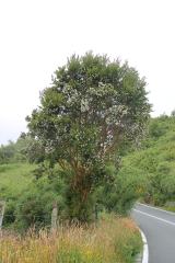 Chilean myrtle5.1 mi
Explorer Tom Chilean myrtle is here in Cork, which is like finding a parrot in a snowstorm; it’s brave but also freezing. A local…
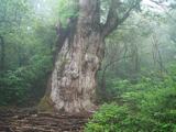 Japanese cedar5.4 mi
Explorer Tom Japanese cedar in County Cork rates its visitors on a strict scale of ‘did they touch the bark’. You’re probably a…
More archaeology and monuments in County Cork · All of County Cork

What do you know about this place?Tap to add a comment or ask a question