DDiscover AloneMapAbout

Field boundary in Mountcharles

Field boundary
Computer-made picture that does not show Field boundary in MountcharlesNot a photo of this monument
Computer-made picture. It does not show this monument. · Report the wrong picture

The monument record does not grant public access. Check the route and ask the landowner before entering private land.

What do you know about this place?Tap to add a comment or ask a question

What you write will be public.

What is recorded here

In the NW corner of a field of rush-grown pasture, on the N outskirts of Mountcharles village, located on the S-facing slope of a ridge, overlooking Donegal Bay to SE. A discrete length of field boundary (L c. 40m), on a roughly N−S axis, is evident as a moss-covered stone and earth bank (Wth 1-1.2m; H 0.2-0.4m). It…

Read the whole record
In the NW corner of a field of rush-grown pasture, on the N outskirts of Mountcharles village, located on the S-facing slope of a ridge, overlooking Donegal Bay to SE. A discrete length of field boundary (L c. 40m), on a roughly N−S axis, is evident as a moss-covered stone and earth bank (Wth 1-1.2m; H 0.2-0.4m). It is not shown on any edition of the OS 6-inch maps. The remains are low and poorly preserved, and its full original extent is unknown: at its N end it peters out close to the N boundary of the field -this section is partly concealed by a thicket of brambles; towards its S end it arcs gently to SW and also peters out. A few large stones or boulders lie close to, but not directly on the line of the field boundary. These appear to be field clearance stones dumped against the field boundary. The surrounding ground surface in the field is uneven and undulating. The southern section of the field boundary differs significantly in character. It consists of a row (L c. 10m) of 10-12 large stones and boulders, set between 0.2-0.6m apart. The majority of stones in the row are roughly square or rectangular blocks of stones (max. L c. 1m N-S; Wth c. 0.3-0.45m E−W; H 0.3-0.6m), relatively low in height; the stones at the N end of the row are lowest and merge with the main body of the earth and stone field boundary. However, three stones, more or less in the centre of the row, are conspicuously tall and upright. The three tall uprights (c. 0.5 by 0.6m; H 1.2-1.45m) are rectangular in basal cross-section, but have sharply angular sides that tapers towards a pointed apex, giving each a roughly triangular appearance. They are not contiguous at their bases, but the most northerly of the three tilts to S and leans against the middle stone, and the middle stone leans against the most southerly of the three. They stand firmly and solidly, but nevertheless do not appear to be deeply set in the ground. The date of the field boundary as a whole is unknown. The significance of the row of stones -and of the three tall stones, in particular - is uncertain. Some of the large stones may be later additions to the field boundary, but it is also possible the row of stones is part of an earlier wall or structure that was incorporated into the earth and stone boundary. Attached images: DG093-026----_01.JPG Field boundary, viewed from N DG093-026----_02.JPG Row of stones at the S end of the field boundary DG093-026----_03.JPG Three upright stones in the row of stones at S end of field boundary Compiled by: Jane O'Shaughnessy Date of upload: 17 November 2020

From the National Monuments Service (Archaeological Survey of Ireland) record DG093-026

Places near here

Photo credits
  • National Inventory of Architectural Heritage
  • Maker not stated on source page, readymap.irish
  • Kenneth Allen, Geograph · CC BY-SA 2.0
  • P L Chadwick, Geograph · CC BY-SA 2.0
  • Donegal GAA; photographer not stated, donegalgaa.ie
  • Maker not stated on source page, in.pinterest.com
  • Maker not stated on source page, www.flickr.com
  • Maker not stated on source page, www.airbnb.ca
  • Maker not stated on source page, au.pinterest.com
  • N Chadwick, Geograph · CC BY-SA 2.0
water pump416 yd

Explorer Tom Water pump in Mountcharles has a big old turning wheel that looks like it’s waiting for someone to spin it. Built c.…
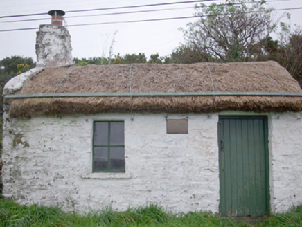
Paddy Kelly's CottageHouse · 437 yd

Explorer Tom Paddy Kelly's Cottage has metal pegs on its eaves that look like it’s trying to dock in the sky. Built around 1820, I…

Kitty Joe’s CafeCafé · 455 yd

Explorer Tom Kitty Joe’s Cafe is open till four, so don’t stay up too late dreaming about coffee or the cat inside might be judging…

Gillespie BrosHouse · 535 yd

Explorer Tom Gillespie Bros has an integral square-headed carriage-arch that looks like it is checking every horse’s height before…

Kozy Kip BarHouse · 572 yd

Explorer Tom Kozy Kip Bar combines two buildings from about 1790. One side kept a timber shopfront dating to about 1860, while the…
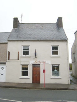
Historic buildingOfficially recorded historic building · 595 yd

Explorer Tom The historic building in Mountcharles began as a house around 1800 and later served as a public house until about 2006.…

Gerald Gallagher Memorial Park, St. Naul's GAA, MountcharlesGAA ground · 668 ydStanding stone in DrumkeelanStanding stone · 1454 yd

Explorer Tom This standing stone in Drumkeelan has a long-standing grudge against the weather for making it look so skinny and lanky…

Drumkeelan Megalithic TombMegalithic tomb · 1.0 mi

Explorer Tom Drumkeelan Megalithic Tomb sits on a quarry face with a sheer drop to the north, which is either brilliant or…

Edrim GraveyardCemetery · 1.3 mi

Explorer Tom Edrim Graveyard would ace a job interview by claiming it has excellent references from the dead, which is technically…

Old Edrim GraveyardCemetery · 1.3 mi

Explorer Tom Old Edrim Graveyard is definitely hiding a secret about why the locals stop talking when it comes up in conversation. I…

Salthill CabinCafé · 1.4 mi

Explorer Tom Salthill Cabin near Mountcharles is likely just a shed with a coffee machine and serious delusions of grandeur. It’s in…

More archaeology and monuments in County Donegal · All of County Donegal

Add to this placeAdd a picture Add a detailed tip Add a story

Explore the map1,095,414 places to discover

Next place · or swipewater pump