
What is recorded here
This feature has been listed as a possible megalithic tomb in the SMR for County Donegal (1987) and as a court tomb in the RMP for County Donegal (1995). It stands at the N end of a boggy plateau, 350m NW of Glencoagh Lough, and on top of a quarry face with a sheer drop to the N. The feature consists of a long,…
Read the whole record
From the National Monuments Service (Archaeological Survey of Ireland) record DG093-005
Places near here
Photo credits
- Maker not stated on source page, in.pinterest.com
- National Inventory of Architectural Heritage
- Maker not stated on source page, ca.pinterest.com
- Andreas F. Borchert, Wikimedia Commons · CC BY-SA 4.0
- Maker not stated on source page, readymap.irish
- Donegal GAA; photographer not stated, donegalgaa.ie
- Kenneth Allen, Geograph · CC BY-SA 2.0
- P L Chadwick, Geograph · CC BY-SA 2.0
- Maker not stated on source page, genius.com
- Maker not stated on source page, www.airbnb.ca
- Maker not stated on source page, commons.wikimedia.org
 Standing stone in DrumkeelanStanding stone · 838 yd
Explorer Tom This standing stone in Drumkeelan has a long-standing grudge against the weather for making it look so skinny and lanky…
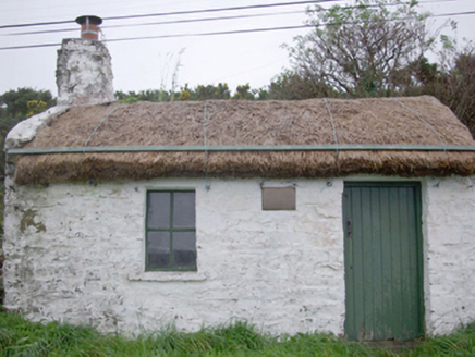 Paddy Kelly's CottageHouse · 1.2 mi
Explorer Tom Paddy Kelly's Cottage has metal pegs on its eaves that look like it’s trying to dock in the sky. Built around 1820, I…
 Mapped cemeteryCemetery · 1.2 mi
Explorer Tom Mapped cemetery claims its best friend is a local seagull named Kevin who guards the back row from any potential…
 St. Mary's Catholic ChurchChurch/chapel · 1.2 mi
Explorer Tom St. Mary's Catholic Church in Drumard hosted a priest who lost a bet and had to wear a wig for a whole Sunday service.…
 water pump1.3 mi
Explorer Tom Water pump in Mountcharles has a big old turning wheel that looks like it’s waiting for someone to spin it. Built c.…
 Kitty Joe’s CafeCafé · 1.3 mi
Explorer Tom Kitty Joe’s Cafe is open till four, so don’t stay up too late dreaming about coffee or the cat inside might be judging…
 Gerald Gallagher Memorial Park, St. Naul's GAA, MountcharlesGAA ground · 1.3 mi
 Gillespie BrosHouse · 1.3 mi
Explorer Tom Gillespie Bros has an integral square-headed carriage-arch that looks like it is checking every horse’s height before…
 Kozy Kip BarHouse · 1.4 mi
Explorer Tom Kozy Kip Bar combines two buildings from about 1790. One side kept a timber shopfront dating to about 1860, while the…
 Fairy fort / earthen ringfort in Dromore (ballintra Ed)Fairy fort / earthen ringfort · 1.9 mi
Explorer Tom Fairy fort / earthen ringfort in Dromore is just an arc of bank on a drumlin, fading out at both ends into modern field…
 Edrim GraveyardCemetery · 2.1 mi
Explorer Tom Edrim Graveyard would ace a job interview by claiming it has excellent references from the dead, which is technically…
 O'Neils PubPub · 2.3 mi
Explorer Tom O'Neils Pub in County Donegal is probably full of people talking about the weather. No address provided, so it might be…
More archaeology and monuments in County Donegal · All of County Donegal

What do you know about this place?Tap to add a comment or ask a question