
What is recorded here
From the National Monuments Service (Archaeological Survey of Ireland) record MA042-032001
Places near here
Photo credits
- National Inventory of Architectural Heritage
- MickReynolds, Wikimedia Commons · CC BY-SA 4.0
- Maker not stated on source page, www.alamy.com
- Maker not stated on source page, commons.wikimedia.org
- Maker not stated on source page, ca.pinterest.com
- John Lucas, Geograph · CC BY-SA 2.0
- Turkishbob at English Wikipedia, Wikimedia Commons · CC BY 2.5
- N Chadwick, Geograph · CC BY-SA 2.0
- Golfing in Ireland; photographer not stated, Source publisher
- Maker not stated on source page, ru.pinterest.com
 Mountain ViewHouse · 558 yd
Explorer Tom Mountain View in Doogort has the weather's personal grudge written all over it. It sits there looking proud while the…
 Saint Thomas's Church (Doogort)Church/chapel · 1098 yd
Explorer Tom Saint Thomas's Church (Doogort) is doing its best to look dignified with that sparrow-pecked stonework, which I think…
 Pagan cemeteryCourt tomb · 1422 yd
Explorer Tom Pagan cemetery in Bal of Dookinelly is guarding its secrets tight against nosey neighbours. It’s just a big pile of…
 Megalithic tomb in Bal of Dookinelly (calvy)Megalithic tomb · 1575 yd
Explorer Tom Megalithic tomb in Bal Of Dookinelly is jealous of the bigger stones down the road that get all the tourist attention.…
 Achill Island BluewayVisitor information · 1596 yd
Explorer Tom The Achill Island Blueway is where fairies have been fighting over parking rights since the last ice age, and frankly…
 Doogort BeachBeach / strand · 1.0 mi
Explorer Tom Doogort Beach, on Achill Island's north shore, has a mountain at its back and Blacksod Bay in front, as if someone gave…
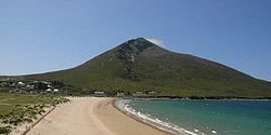 SlievemoreMountain / peak · 1.3 mi
Explorer Tom Slievemore rises over Achill Island with a long stony shoulder above a roofless village. From below, the old houses…
 Slievemore Old GraveyardCemetery · 1.7 mi
Explorer Tom Slievemore Old Graveyard in County Mayo has a prophecy that it would float away on a Tuesday, which never happened…
 Wild Atlantic Way:Visitor information · 1.8 mi
Explorer Tom Another Wild Atlantic Way? Right, so this one would complain to the council that the clouds keep stealing its spotlight…
 Golden StrandBeach / strand · 2.0 mi
Explorer Tom Golden Strand at Dugort sounds like the sort of place where pirates would bury a chest, then lose the map in a gust and…
 Achill Island Golf ClubGolf course · 2.1 mi
 Bunacurry New CemeteryCemetery · 2.3 mi
Explorer Tom Bunacurry New Cemetery is trying too hard to impress Saint Patrick, who probably just sees a muddy patch of earth with…
More archaeology and monuments in County Mayo · All of County Mayo

What do you know about this place?Tap to add a comment or ask a question