What is recorded here
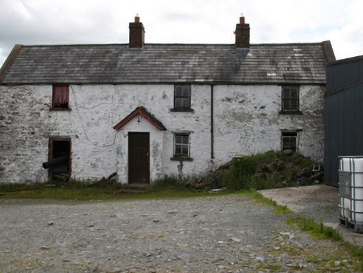
Attached lobby-entry three-bay two-storey farmhouse, built c.1800, with gabled windbreak porch, single-storey outbuilding to east of c. 1920, recent metal shed to west, c.1990, now vacant. Pitched roof with slate to front and replacement slate to rear, two redbrick chimneystacks to central section, rendered barge copings and sections of cast-iron rainwater goods. Roughcast rendered wall of random rubble construction. Timber lintels and stone sills to window openings in north elevation with two-over-two timber sash windows having exposed sash boxes, bay to east end having timber sheeted loft shutter to first floor window and door opening at ground floor. One two-over-two sash window to rear and half walled large opening with recent fixed timber window. Gabled slate roof to porch with timber barge and recent timber door. Two-bay single-storey rubble stone outbuilding to side with recent corrugated metal roof, door opening and brick segmental arch headed integral carriageway.
An interesting early nineteenth century farmhouse which retains much of its distinctive vernacular form, layout and materials. The position of the house nestled into the side of a hill and the laneway approach demonstrate the traditional manner of setting a house in the landscape. Though two-storey, the house follows the traditional hearth-lobby plan type characteristic of Irish rural vernacular architecture. It retains sash windows with exposed boxes, which further reinforce its vernacular aspect, while the use of the eastern bays as loft and outbuilding demonstrate the close relationship between the dwelling and the workings of an historic farm. The house and outbuilding contribute strongly to the historic character of their setting.
From the Buildings of Ireland (National Inventory of Architectural Heritage) record 40402902
This does not grant access. Most recorded buildings are privately owned; view them only from public ground unless the owner allows entry.
Places near here
 St Joseph's Roman Catholic ChurchChurch/chapel · 178 ydCornamaghMountain / peak · 1716 ydBracklinMountain / peak · 1.9 mi
 Laurel MountHouse · 2.0 mi
 Fair of MuffVisitor information · 2.5 mi
 Fair of MuffMemorial · 2.5 mi
 LoughanleaghForest · 2.7 mi
 Horse-chestnut3.4 mi
 Graveyard3.5 mi
 Bush IslandIslet · 4.1 mi
 Welcome to Bailieborough DemesneVisitor information · 4.2 mi
 Portal tomb in ErveyPortal tomb · 4.7 mi
Pictures: Kieran Campbell, Geograph · Creative Commons Attribution-ShareAlike 2.0; National Inventory of Architectural Heritage; Oliver Dixon, Geograph · CC BY-SA 2.0; Stephan van Helden, Wikimedia Commons · CC BY-SA 4.0; Eric Jones, Geograph · Creative Commons Attribution-ShareAlike 2.0; Wanfried-Dublin, Wikimedia Commons · CC BY-SA 4.0
More historic places in County Cavan · All of County Cavan
What do you know about this place?