What is recorded here
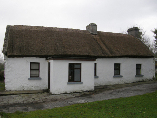
Detached five-bay single-storey direct entry thatched farmhouse with dormer attic, extant 1838, originally three- or four-bay single-storey with single-bay single-storey flat-roofed projecting porch. Extended, pre-1923, producing present composition. Refenestrated. Reroofed, 2002. Vacated, 2009. Sold, 2011. Pitched roof with replacement reed thatch, remains of rope twist above exposed hazel or willow lattice stretchers to ridge having exposed scallops, cement rendered chimney stack having stepped capping supporting terracotta pot, and concrete or rendered coping to gables with cement rendered chimney stack to apex (east) having "Cavetto"-detailed stringcourse below capping. Limewashed rendered battered walls; cement rendered surface finish to side (east) elevation. Square-headed window openings with concrete sills, and concealed dressings framing replacement timber casement windows. Square-headed opposing door openings with concealed dressings framing timber doors. Interior including kitchen retaining hearth, opposing loft ladder with timber balusters supporting timber banister terminating in timber newel, and timber boarded or tongue-and-groove timber panelled vaulted ceiling. Set in unkempt grounds perpendicular to road with limewashed piers to perimeter having capping supporting flat iron "farm gate".
A farmhouse identified as an integral component of the vernacular heritage of the environs of Neale by such traits as the alignment perpendicular to the road; the lengthy direct entry plan form; the construction in unrefined local fieldstone demonstrating a feint battered silhouette; the somewhat disproportionate bias of solid to void in the massing; and the high pitched roof showing a replenished reed thatch finish: meanwhile, a comparison of the second (surveyed 1894; published 1896) and third (surveyed 1923-4; published 1929) editions of the Ordnance Survey illustrates the continued linear development of the farmhouse in the early twentieth century.
This does not grant access. Most recorded buildings are privately owned; view them only from public ground unless the owner allows entry.
Places near here
 Enclosure in CashlancranEnclosure · 734 yd
 Enclosure in Cahernagry WestEnclosure · 979 yd
 The Neale Cottagehouse · 1192 yd
 Neale Housefolly · 1.0 mi
 Bawn in Kilkeeran (kilmaine By., Kilmainebeg Par.)Bawn · 1.6 mi
 Castle in ruinsCastle, tower house · 2.4 mi
 European ashEuropean ash · 3.4 mi
 LabbadermotCave · 3.4 mi
 Gibbs IslandsIslet · 3.8 mi
 Easter IslandIslet · 3.9 mi
 Cong AbbeyHeritage attraction · 4.4 mi
 Quiet Man MuseumMuseum · 4.4 mi
Other information
Photo: National Inventory of Architectural Heritage · Website use allowed for educational or private purposes with source credit