What is recorded here
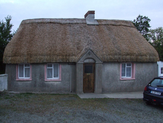
Detached four-bay single-storey lobby entry thatched farmhouse with dormer attic, extant 1840, on a T-shaped plan centred on single-bay single-storey gabled windbreak. Refenestrated, ----. Reroofed, ----. Replacement hipped oat thatch roof with chicken wire-covered exposed hazel stretchers to raised ridge having exposed scallops, rendered off-central chimney stack having red brick stepped capping, and exposed hazel stretchers to eaves having exposed scallops. Roughcast battered walls on rendered plinth with rendered "bas-relief" strips to corners supporting rendered band to eaves. Square-headed central door opening in segmental-headed recess with concrete threshold, and concealed dressings framing replacement glazed timber boarded or tongue-and-groove timber panelled door. Remodelled square-headed window openings with concrete sills, and rendered "bas-relief" surrounds framing replacement timber casement windows. Square-headed window openings to gables to side elevations with concealed dressings framing two-over-two timber sash windows having part exposed sash boxes. Set in farmyard on a corner site with rendered diagonal piers to perimeter having pyramidal capping supporting tubular steel "farm gate".
A farmhouse identified as an integral component of the vernacular heritage of County Wexford by such attributes as the rectilinear lobby entry plan form centred on a characteristic windbreak; the construction in unrefined local materials displaying a battered silhouette with sections of "daub" or mud suggested by an entry in the "House and Building Return" Form of the National Census (NA 1901; NA 1911); and the high pitched roof showing a replenished oat thatch finish. Furthermore, adjacent "tin roofed" outbuildings (extant 1903) continue to contribute positively to the group and setting values of a neat self-contained ensemble making a pleasing visual statement in a rural street scene.
From the Buildings of Ireland (National Inventory of Architectural Heritage) record 15703344
This does not grant access. Most recorded buildings are privately owned; view them only from public ground unless the owner allows entry.
Places near here
Photo credits
- National Inventory of Architectural Heritage
- Sarah777 at English Wikipedia, Wikimedia Commons · Public domain
- Chris, Wikimedia Commons · CC BY-SA 2.0
- Michal Osmenda, Wikimedia Commons · CC BY-SA 2.0
- Thommcg1980, Wikimedia Commons · CC BY-SA 4.0
- AFBorchert, Wikimedia Commons · CC BY-SA 4.0
- Danielclauzier, Wikimedia Commons · CC BY-SA 3.0
- Maker named on the Wikimedia Commons picture page · CC BY-SA 3.0
CastleCastle, motte · 770 yd farm house853 ydFont (present location) in Ballinacoola MoreFont (present location) · 996 ydfarm house1134 ydSt. Margarets WellHoly well · 1.3 miCurracloe BeachBeach / strand · 1.5 miRaven Point Nature ReserveForest · 1.9 miBallinesker BeachBeach / strand · 2.0 miCommodore John Barry MemorialMemorial · 4.1 miSiege of WexfordSiege · 4.2 miSack of WexfordSiege · 4.2 miDawn Redwood6.2 mi
 farm house853 ydFont (present location) in Ballinacoola MoreFont (present location) · 996 yd
 farm house1134 ydSt. Margarets WellHoly well · 1.3 mi
 Curracloe BeachBeach / strand · 1.5 mi
 Raven Point Nature ReserveForest · 1.9 mi
 Ballinesker BeachBeach / strand · 2.0 mi
 Commodore John Barry MemorialMemorial · 4.1 mi
 Siege of WexfordSiege · 4.2 mi
 Sack of WexfordSiege · 4.2 mi
 Dawn Redwood6.2 mi
More historic places in County Wexford · All of County Wexford
What do you know about this place?