What is recorded here
This wood once formed part of the Salter Townsend estate whose residence was at nearby Castletownsend. Historical features ... include a sturdy stone wall known as the “Famine” wall, built during the famine to keep deer within the estate.
From OpenStreetMap (© OpenStreetMap contributors) w379538950
Places near here
Photo credits
- National Inventory of Architectural Heritage
- Garry Dickinson, Wikimedia Commons · CC BY-SA 2.0
IndicatedField boundary · 13 ydRineen Forest Recreation AreaWood · 240 ydSéipéal an StuaicínArchaeological place · 314 ydOileáin CraobhachIslet · 519 ydLeaca RiabhachWood · 660 ydCuaisín a' TarbhBay · 709 yd Rinneen MillsHouse · 855 ydwater pump888 ydNancy's HillMountain / peak · 956 ydLookoutMountain / peak · 1081 ydRodger's IslandIslet · 1182 ydRaheen CastleCastle · 1631 yd
 Rinneen MillsHouse · 855 yd
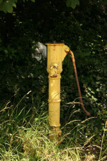 water pump888 ydNancy's HillMountain / peak · 956 ydLookoutMountain / peak · 1081 ydRodger's IslandIslet · 1182 yd
_-_geograph.org.uk_-_6532839.jpg/250px-Castles_of_Munster,_Raheen,_Cork_(2)_-_geograph.org.uk_-_6532839.jpg "Photo: Garry Dickinson, Wikimedia Commons · CC BY-SA 2.0") Raheen CastleCastle · 1631 yd
Raheen CastleCastle · 1631 ydMore historic places in County Cork · All of County Cork
What do you know about this place?