
What is recorded here
From OpenStreetMap (© OpenStreetMap contributors) n2280129063
Places near here
Photo credits
- Maker not stated on source page, www.flickr.com
- Maker not stated on source page, ru.pinterest.com
- Maker not stated on source page, ms.fusedlearning.com
- Maker not stated on source page, en.wikipedia.org
- National Inventory of Architectural Heritage
- Jonjobaker, Wikimedia Commons · CC BY-SA 4.0
- Maker not stated on source page, www.dreamstime.com
 Fairy fort / earthen ringfort in Donaghmore (ratoath By.)Fairy fort / earthen ringfort · 1133 yd
Explorer Tom Fairy fort / earthen ringfort in Donaghmore: The weather has a long-standing grudge against this ring, probably because…
 Fairy fort / earthen ringfort in WottonFairy fort / earthen ringfort · 1.5 mi
Explorer Tom Fairy fort in Wotton has walls thin enough to hear the neighbours arguing about the bin. It’s a small circle that…
 Fairy fort / earthen ringfort in KilleglandFairy fort / earthen ringfort · 1.7 mi
Explorer Tom Fairy fort / earthen ringfort in Killegland had an escape plan involving a stream and a lot of mud. Its first owner…
 Enclosure in Rath (ratoath By., Greenoge Par.)Enclosure · 1.7 mi
Explorer Tom Enclosure in Rath would say in a job interview that it has strong roots and excellent visibility from the air, which is…
 Jordanstown HouseFarm house · 2.6 mi
Explorer Tom Jordanstown House is an 1850 farmhouse with original crown glass windows that are definitely seeing things from way…
 presbytery/parochial/curate's house3.3 mi
Explorer Tom The presbytery in Oldtown would post a selfie of its uPVC porch with the caption 'living my best 1870 life' and get…
 Catholic Church of Our Lady Queen of PeaceChurch/chapel · 3.3 mi
Explorer Tom Catholic Church of Our Lady Queen of Peace is a gable-fronted church built in 1962 where the shortcut to the back…
 Oldtown HallHall · 3.3 mi
Explorer Tom Oldtown Hall is a corrugated-iron hall from 1880. It’s got carved barge boards that are surprisingly artistic for…
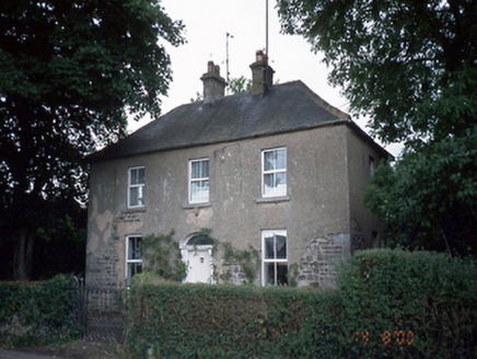 Oldtown HouseHouse · 3.3 mi
Explorer Tom Oldtown House has gone through so many names that it’s basically an impostor wearing a 1850s coat and an original…
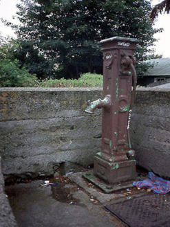 water pump3.3 mi
Explorer Tom Water pump in Oldtown is wearing its Balrothery District Council inscription like a badge of honour, probably because…
 bridge3.3 mi
Explorer Tom Bridge in Oldtown is a single-span rubble stone road bridge from around 1900 that was nearly sold for a horse in a deal…
 Mapped graveyardGraveyard · 3.3 mi
Explorer Tom Mapped graveyard has a ghost that’s too lazy to haunt it properly, preferring instead to sit on a bench and watch the…
More archaeology and monuments in County Meath · All of County Meath

What do you know about this place?Tap to add a comment or ask a question