DDiscover AloneMapAbout

Fahan Graveyard

Graveyard

The monument record does not grant public access. Check the route and ask the landowner before entering private land.

What survives
Recorded monument
What do you know about this place?Tap to add a comment or ask a question

What you write will be public.

What is recorded here

The early ecclesiastical site of Fahan consists of a modern graveyard, at a bend in the road. It is possible that this bend may reflect something of an earlier enclosure. Inside the graveyard (DG038-013004-) is part of a ruined church. Fahan old Church (DG038-013001-): In 1622, the parish church was 'well and…

Read the whole record
The early ecclesiastical site of Fahan consists of a modern graveyard, at a bend in the road. It is possible that this bend may reflect something of an earlier enclosure. Inside the graveyard (DG038-013004-) is part of a ruined church. Fahan old Church (DG038-013001-): In 1622, the parish church was 'well and sufficiently repaired' (Royal Commission, 191) and it continued in use until the new church was built in 1820 (Rowan 1979, 289). Only the E gable at full height and 5.67m wide internally, and adjoining sections of N and S walls survive. A low cross wall now devoid of railings at the W end of the latter encloses the burial plot of the Hawkshaw family whose memorial is set below the E window. The walls are built of rubble and the E gable has two antae-like projections; ivy has partly dislodged that on the S. The three-light round-headed E window has simple switch-line tracery and four rows of transverse iron glazing bars. It is probably of 17th century date. There is a blocked-up rectangular window, .76m high with simple jambs and splayed ingoings in the S wall. The general style and dressing is different to that of the E window and point to its being of an undoubtedly earlier date. The exterior of the church is harled and the interior preserves sections of two superimposed coats of plaster. SE of the church is St. Mura's cross-slab (DG038-013002-). The slab is 2.1m high × 1.04m N-S and·.18m thick. The top of the slab has been worked into a triangular shape. A narrow band around the edges, frames the slab on both sides. On each side is carved a cross formed of broad double-edged interlaced ribbon. On both faces this consists of a Greek cross mounted on a stem giving the effect of a Latin cross. There is a boss at the centre of each cross. On the E face of the slab there are two small concentric circles around a small boss, in each of the hollowed angles of the cross. Two rudimentary arms protrude from the slab at a point coinciding with the arms of the cross on the E face. Also on this face, in the triangular space above the cross, are two affronted birds. On the W face of the slab a figure can be seen on either side of the cross stem. It has been suggested by Macalister, that patterns on the dress of each figure are inscriptions; however, this has been rejected by Henry (1965, 125-8). Also on the W face the cross stem expands outwards beneath the figures and acts almost as a platform. Macalister also read the doxology 'Glory and honour to the father the son' and holy spirit', inscribed in Greek characters on the N edge of the slab. This reading has been accepted by other scholars. On the outside wall of the graveyard on the S side of the entrance is a small slab (DG038-013003-) .41mx .32m. On this is a carved wheeled cross. This stone is very similar to another found near. Clonca (DG012-002001-). On the other side of the entrance is a stone (DG038-013007-) .66m × 0.5m built into the wall. Through this is bored a hole 14.5 cms in diameter. The site of Fahan is situated in a valley at the foot of Collan Hill and Carrick Hill close to the shore of Lough Swilly. About 350m NW of the churchyard and close to the shore is a holy well (DG038-012-) dedicated to St. Mura (Ó Muirgheasa No. 89). (Crawford 1980, 29; Gwynn and Hadcock 1970, 36; Macalister 1949, 118 20, No. 951; Spence 1910-11, 17-31) (see also DG004-005001-) The above description was derived from the 'Archaeological Survey of County Donegal. A description of the field antiquities of the County from the Mesolithic Period to the 17th century.' Compiled by: Brian Lacey with Eamon Cody, Claire Cotter, Judy Cuppage, Noel Dunne, Vincent Hurley, Celie O'Rahilly, Paul Walsh and Seán Ó Nualláin (Lifford: Donegal County Council, 1983). NGR 234400/426350 Tim Coughlan undertook monitoring of a strip 115m long and with a variable width of 2-15m at this site in July 2000 (see below No. 177). The site was within 20m of an ecclesiastical site and graveyard. Monitoring, carried out on behalf of Donegal County Council, failed to reveal any features or finds of archaeological interest. Later, the writer received a phone call from Dúchas The Heritage Service stating that human bone had been found in an area north of that monitored by Mr Coughlan (but outside the archaeological monitoring area). The writer was on site on 7 and 8 September to record any features uncovered and to ensure that there was no further impact on the archaeological resource through permitted development. All skeletal material had been removed before arrival on site. It was subsequently examined by Dr Marie Cassidy, Department of Forensic Medicine, Trinity College, Dublin. She confirmed the remains to be of an adult, which could represent a single person. There was insufficient material to determine whether this was male or female. It was concluded that the remains were not modern and possibly well in excess of 100 years old. Archaeological excavation and recording revealed that the human remains came from a cut, measuring 1.2m east-west by 0.8m. There were two fills, with the primary fill containing redeposited natural with large stone inclusions, while the upper fill consisted of loose, black, slightly silty clay with tree root and large stone inclusions. It was reported by the workers on site that the human remains came from this upper fill. Excavation proceeded to a depth of 1.3m, at which point the base of the cut had not been revealed. This negative feature was seen to truncate the previous road surface and can therefore be claimed to be of recent origin. An area measuring 30m (east-west) x 8.5m, located slightly to the west of where the human remains were found, was required to facilitate development. Excavation in this area was monitored. Excavation revealed one circular negative feature, measuring 0.41m north-south x 0.4m, cut into natural. The fill consisted of a friable, brown clay with animal bones, small shell fragments and possibly a small number of human bone remains (awaiting detailed analysis). Excavation revealed vertical sides and a flat base. At the western end of the excavated area an east-west layer was recorded. This was truncated by an already existing sewer on its southern side and by the existing road on its northern side. It measured 7.5m east-west x 0.95m. It had a single fill of friable, silty clay with moderate stone and shell inclusions. No datable material was recovered. (Excavations Bulletin 2000) Dermot Nelis, Irish Archaeological Consultancy, 8 Dungar Terrace, Dun Laoghaire, Co. Dublin. Excavation licence number 00E0721 Testing was carried out on the site of a proposed housing development in Fahan, Co. Donegal. The proposed development entails the construction of ten two-storey detached dwelling-houses and associated services. Testing was also carried out at the location of 19 of 41 further proposed dwelling-houses for which outline planning permission has been confirmed. The site is located on a west-facing hillside to the north-east of Fahan graveyard and Glebe. It is bounded to the south-west by a low wall and laneway, separating the proposed development from the ecclesiastical site. The site is located on a gently rising, west-facing hillside, which affords good views south-west to Inch Island and Lough Swilly. Testing was carried out on 25 September 2000. Using a toothless trenching bucket, 29 test-trenches were excavated. Decaying/shattered bedrock was sealed by a series of natural, compact, grey/brown clays and loose, grey, sandy clays that in turn underlay topsoil and sod. Nothing of archaeological significance was observed. (Excavations Bulletin 2000) Declan Moore, Moore Archaeological and Environmental Services Ltd, 200 Dún na Coiribe, Galway.

From the National Monuments Service (Archaeological Survey of Ireland) record DG038-013004

Places near here

Picture notes
  • National Inventory of Architectural Heritage
  • Andreas F. Borchert, Wikimedia Commons · CC BY-SA 4.0
  • David Dixon, Geograph · CC BY-SA 2.0
  • Kenneth Allen, Wikimedia Commons · CC BY-SA 2.0
  • Pampuco, Wikimedia Commons · CC BY-SA 4.0
  • Oliver Dixon, Wikimedia Commons · CC BY-SA 2.0
  • Kenneth Allen, Geograph · CC BY-SA 2.0
  • Ronnie Nijboer, Wikimedia Commons · CC0
  • Computer-made picture. It does not show this playground.
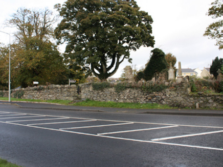
graveyard/cemetery8 yd

Explorer Tom Graveyard or cemetery in Glebe is home to St. Mura’s Cross, which has a Greek inscription on it, unique for Ireland! It’s a gentle spot to visit, where you can also pay respects to Agnes Elizabeth Jones, the nurse who trained with Florence Nightingale.

Fahan Old ChurchChurch · 8 yd

Explorer Tom Fahan Old Church was still in use after a recorded repair in 1622, then gave way to a new church in 1820. The survey found its east gable at full height with a three-light window; one wall made a rather determined farewell.
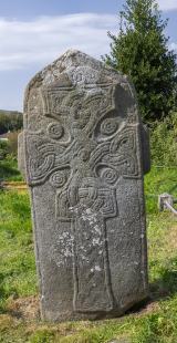
Cross in Glebe (fahan Ed)Cross · 13 yd

Explorer Tom Cross in Glebe is a slab that’s been arguing with scholars for centuries. It has two figures standing on either side of the cross, and their clothing is covered in inscriptions nobody can properly decipher yet. Add the Greek doxology carved down the edge, and it feels like a puzzle box from another world.

LisfannonOfficial bathing water · 1.3 mi

Explorer Tom Lisfannon is the sort of beach that changes its stage set with the tide. The Swilly estuary lays out shallow water, sand and mud flats in turn. A 2019 state report notes otters among the wildlife here. I would watch the stage changes from dry ground and let the tide run the show.

Possible Chambered GravePublicly named tomb or grave · 1.8 mi

Explorer Tom Possible Chambered Grave on Inch Island isn’t even marked on the map, which feels like a secret handshake with history. The name is a bit tentative, but it looks very much like what it says on the tin. I reckon it’s hiding in plain sight, just waiting for someone to nod at it.
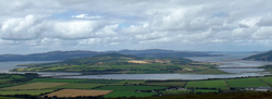
InchIsland · 1.8 mi

Explorer Tom Inch Island sits quietly near Grianan of Aileach, acting like it doesn’t know how famous its neighbour is. It’s keeping to itself, which I respect. Best enjoyed with a bag of chips and no plans whatsoever.

Cashel HillMountain / peak · 2.0 mi

Explorer Tom Cashel Hill in County Donegal makes a low, moaning groan at night that sounds exactly like a ghost who just stubbed its toe on a rock. It’s very dramatic for a hill. Tell it a joke, it's been a long time since anyone did, and it might laugh out loud.

Old CastleCastle, tower house · 2.8 mi

Explorer Tom Old Castle is a stubborn tower house that has survived since 1454, even if Mr. Skinner never finished his rebuild. The east half stands three storeys high with intact vaults and murder holes, while the rest lies in ruins. It’s a proper cliff-edge survivor that refuses to fully crumble away.

RathmullanOfficial bathing water · 2.9 mi

Explorer Tom Rathmullan Beach starts at the pier and keeps strolling past Kinnegar toward the Glebe outcrop. If sand could wear walking boots, this strip would be lacing them up. A 2019 Lough Swilly report also notes otters among the wildlife; I would leave any real otter sighting to patience and luck.

Wych Elm2.9 mi

Explorer Tom Final Wych Elm in County Donegal is packing up its bags after this tour. It needs permission to leave gracefully. Tell it to keep those branches strong and maybe wave goodbye before the wind blows it away.

Children's playground2.9 miComputer-made picture. It does not show this playground.

Explorer Tom Children's playground in County Donegal hits different if you’re hungover and holding a sausage roll. It’s the only way to appreciate the sheer chaos of this lovely spot. Best seen with a hangover and a sausage roll.

Inishowen Gateway HotelHotel · 2.9 mi

Explorer Tom Inishowen Gateway Hotel in Buncrana is right by the river, supposedly at its foot. It’s your gateway to nowhere specific, so take a selfie looking confused and call it a day.

More memorials and graveyards in County Donegal · All of County Donegal

Add to this placeAdd a picture Add a detailed tip Add a story

Explore the map1,118,977 places to discover

Next place · or swipegraveyard/cemetery