What is recorded here
'The site is situated in the townland of Manor West, on top of a substantial limestone reef (50 feet above O.S. Datum, 27mm North-East of S.M.R. Ke029 164 ). The reef has sheer sides, except to the south - south west, where it slopes more gradually down to the surrounding lowlands. The drop to the lowland is greatest on the north-west, where quarrying has partially cut into the reef. The reef affords commanding views of the Tralee area, in all directions and dominates this area of the Lee Valley. The site is not recorded on the sites and Monuments Record for County Kerry. The most southerly portion of the reef, where it slopes gradually down to the lowland, has been stripped of much of its surface material and the underlying limestone bedrock has been broken up. This has been done in connection with a substantial housing development, which bounds the site to the south and west........the major portion of the reef is separated from the development area by an east-west running boundary wall and is generally sub-circular in area, with an approximate diameter of 80m. This portion of the reef is almost completely overgrown with almost impenetrable whitethorn scrub......[the] surviving portion of the reef is partially enclosed by a intermittent, substantial stone and earth bank, which in places remains to a height of approx. 0.8m and is around 10m wide at base. On the north-west side of the reef it is obvious that the enclosing element was bi-vallate, as a second bank, much denuded , is visible outside the first, however there is no trace of a ditch associated with either bank.'
Compiled by Michael Connolly for the Archaeological Survey of Ireland as part of a survey of the Lee Valley area in 1996-97.
'The site is situated in the townland of Manor West, on top of a substantial limestone reef (50 feet above O.S. Datum, 27mm North-East of S.M.R. Ke029 164 ). The reef has sheer sides, except to the south - south west, where it slopes more gradually down to the surrounding lowlands. The drop to the lowland is greatest on the north-west, where quarrying has partially cut into the reef. The reef affords commanding…
From the National Monuments Service (Archaeological Survey of Ireland) record KE029-304
This remains an important historical record, but the official description says the monument is no longer visible or has been destroyed. The monument record does not grant public access. Check the route and ask the landowner before entering private land.
- What survives
- No visible remains or recorded as destroyed
Places near here
Photo credits
- Kierandoc, Wikimedia Commons · CC BY-SA 4.0
- ATJWen, Wikimedia Commons · CC BY-SA 4.0
- National Inventory of Architectural Heritage
- Robert Linsdell from St. Andrews, Canada, Wikimedia Commons · CC BY 2.0
- Sitomon, Wikimedia Commons · CC BY-SA 2.0
- Wikimedia Commons contributor · CC BY-SA 3.0
- Patrick Wyse Jackson, Wikimedia Commons · CC BY-SA 4.0
- Willow, Wikimedia Commons · CC BY 2.5
Enclosure in Manor WestEnclosure · 351 yd Ratass Church (in ruins)Church · 664 ydOgham stone in RatassOgham stone · 669 ydCastlemorris HouseHouse · 819 ydCivil War MemorialMemorial · 1106 ydEuropean Yew1302 ydCastleCastle, unclassified · 1719 ydKerry County MuseumMuseum · 1.1 miThe PikemanMemorial · 1.2 miCastleCastle, unclassified · 1.2 miJohn Hurley GalleryGallery · 1.2 miCommon Alder1.7 mi
 Ratass Church (in ruins)Church · 664 yd
 Ogham stone in RatassOgham stone · 669 yd
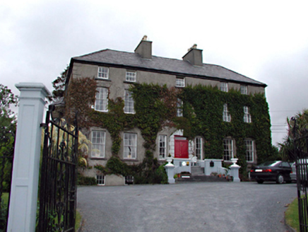 Castlemorris HouseHouse · 819 yd
_(27283083824).jpg/250px-Civil_War_Memorial._Church_St,_Ring_of_Kerry,_Cahersiveen_(506519)_(27283083824).jpg "Photo: Robert Linsdell from St. Andrews, Canada, Wikimedia Commons · CC BY 2.0") Civil War MemorialMemorial · 1106 yd
Civil War MemorialMemorial · 1106 yd European Yew1302 ydCastleCastle, unclassified · 1719 yd
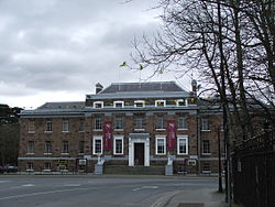 Kerry County MuseumMuseum · 1.1 mi
 The PikemanMemorial · 1.2 miCastleCastle, unclassified · 1.2 miJohn Hurley GalleryGallery · 1.2 mi
 Common Alder1.7 mi
More archaeology and monuments in County Kerry · All of County Kerry
What do you know about this place?