
Places near here
Photo credits
- National Inventory of Architectural Heritage
- VisionsofthePast, Wikimedia Commons · CC BY-SA 4.0
- The Speckled Bird, Wikimedia Commons · CC BY-SA 4.0
- Colin Park, Wikimedia Commons · CC BY-SA 2.0
- Hywel Williams, Geograph · Creative Commons Attribution-ShareAlike 2.0
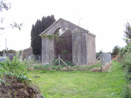 mausoleum509 yd
Explorer Tom The Jackson family mausoleum in Killathy is having a full-on classical mood swing with its Doric columns and carved arches. It’s basically a fancy box for people who didn’t want to be buried in a trench. If it rains, blame your umbrella.
 railway station1626 yd
Explorer Tom Railway station in Ballyhooly South is now just domestic houses on an L-plan. The goods shed has some serious stone arch craftsmanship that’s begging for attention. It’s like the tracks stopped running but the romance didn’t quite leave the building.
Johnson's WoodForest · 1.5 miExplorer Tom Johnson's Wood would order a massive chipper with extra gravy if it could afford it. It thinks the trees are just vertical fries waiting to be eaten. Look for the ghost, then pretend you did not see him.
Blackwater (Avondhu) WayWalking route · 1.8 miExplorer Tom Blackwater (Avondhu) Way in County Cork is doing that thing where it pretends to be easy but has a secret grudge about your footwear. Rumor says a dance party started here last Tuesday and someone’s still trying to find their partner, which explains the weird footprints you’re seeing right now. Bring the dog, it'll have opinions.
Priest's WoodForest · 1.9 miExplorer Tom Priest’s Wood has a favourite song, which is just the sound of wind through the branches on a Tuesday evening. It thinks it sounds very spiritual and profound, to be honest. Snap one photo, then put the phone away and actually look at what’s around you.
 LabbacalleeWedge tomb · 2.5 mi
Explorer Tom Labbacallee is one of the largest wedge tombs in the country, sitting on a knoll near Funshion River. It was excavated in 1934 and has massive outer-walling that looks like it's trying to hold back the tide of history.
 Glanworth CastleCastle · 2.9 mi
Explorer Tom Glanworth Castle in County Cork is probably dreaming of being a grand mansion instead of just standing there looking slightly tired. It might have a hidden cellar full of old letters and gossip. Peek inside.
 Glanworth Castle (in Ruins)Castle, Anglo-Norman masonry castle · 2.9 mi
Explorer Tom Glanworth Castle in Boherash has a bad poem about it that rhymes 'defence' with 'fence', which is tragic because it actually sits on a promontory overlooking the River Funshion and looks rather impressive doing it. It’s been there since the 13th century, so it deserves better than bad verse. A
Cappagh XViewpoint · 2.9 miExplorer Tom Cappagh X is where two families are having a silent feud over who owns the best view, probably involving a lot of shouting. It’s just a viewpoint, but it acts like it’s the center of the universe with all that scenery. Sit on a wall near it and pretend you're in a painting.
Liam BurkeMemorial · 2.9 miExplorer Tom Liam Burke is a memorial for a volunteer who got killed near here, and honestly, the rabbits on this hill probably think he was just another bad decision made by the British. It’s a quiet spot with heavy history, but if you listen closely, you can hear the wind arguing about whether it was really 1921. Find the date carved somewhere and feel clever.
Graveyard in BoherashGraveyard · 3.0 miExplorer Tom Graveyard in Boherash has been burying folks since 1724, which means it’s seen more fashion disasters than a Paris runway. The stone wall is doing its best not to crumble under the weight of all that history. Stick around for the light changing, it's a show.
 St Bernards WellHoly well · 3.8 mi
Explorer Tom St Bernards Well in Duntahane was built by someone who thought two adjacent wells were enough, but really just created a concrete-lined water system for the River Blackwater to drink from. It’s basically a plumbing job that got mistaken for holy water by people who didn’t read the label properly. Best seen with a hangover and a sausage roll.
More archaeology and monuments in County Cork · All of County Cork

What do you know about this place?Tap to add a comment or ask a question