Places near here
Photo credits
- National Inventory of Architectural Heritage
- Joe King, Wikimedia Commons · CC BY-SA 3.0
- Alan James, Geograph · CC BY-SA 2.0
- JP, Wikimedia Commons · CC BY-SA 2.0
- Syncretists, Wikimedia Commons · CC BY-SA 4.0
- Sarah777, Geograph · CC BY-SA 2.0
 Killakee HouseHouse · 285 yd
Explorer Tom Killakee House nearly made national news when a vicar mistook it for his own home and tried to check in. It’s got layers of history stacked up like a messy attic, but still looks bold from the road. I’d love to know if the plumbing can handle all that drama without complaining.
 Hell Fire ClubRuins · 423 yd
Explorer Tom Hell Fire Club is a ruined folly that refuses to let go of its reputation for wild parties, even though it’s just rocks now. A specific bird refuses to leave, probably because it thinks it’s still running the show from the top shelf. Practise your Irish on it, it won't correct you.
 Montpelier HillMountain / peak · 443 yd
Explorer Tom Dublin has a hill, a view and a lodge with a dreadful reputation. Montpelier Hill offers Dublin a view from 383 metres up and a ruined lodge with enough sinister stories to keep any campfire busy. Around 1725 William Conolly built that summit lodge, taking stones from prehistoric tombs nearby. The later Hellfire Club tales involve wild behaviour and darker rumours; the stone building is real, but the spookiest accounts are stories rather than a reliable guest list. Behind it you can still pick out remains of the old cairn. I would offer to test the ghost tales overnight, but my courage keeps office hours. Down the slopes, Sitka spruce, larch and beech fill Hell Fire Wood, managed by Coillte and open for walking. Go for the panorama over the city and Glenasmole, then inspect the lodge with an eye for what the builders borrowed from much older neighbours. The paths can be muddy and the hill is exposed, so dress for a proper walk. If you hear footsteps behind you, it is probably another walker. Probably.
Dublin Mountains Way Hellfire & Massey SpurWalking route · 569 ydExplorer Tom Another Dublin Mountains Way Hellfire & Massey Spur in County Dublin, apparently the name stuck hard. Maybe the ground is warm from all the walking feet. Don't let the scary name scare you off the path entirely.
 Massey WoodWood · 948 yd
Explorer Tom Massey Wood has an imaginary twin across the sea that’s been sending it postcards about how much better the weather is over there, which Massey ignores with supreme dignity. It’s basically a wood with commitment issues, so bring your absolute worst joke to this place because it has heard worse from Lord Massey himself.
Carty's CastleRuins · 1349 ydExplorer Tom Carty's Castle in County Dublin is just ruins now, but the fairies still argue about who gets to park there first. They've been fighting over that spot since before your great-grandparents knew what a castle was even supposed to look like. Stand still and listen, the wind tells it better than I can possibly manage.
 Mount Venus CemeteryCemetery · 1731 yd
Explorer Tom Mount Venus Cemetery in County Dublin was originally planned as an escape route for a very nervous vicar who couldn’t handle the pressure of his new parish. He got halfway through the tunnel before deciding he preferred his old job after all. A handy spot to stretch your legs and your imagination.
_-_20180125125204.jpg/250px-County_Dublin_-_St_Colmcille's_Well_(Oldcourt)_-_20180125125204.jpg "Photo: Syncretists, Wikimedia Commons · CC BY-SA 4.0") St Columkilles WellHoly well · 1.1 mi
St Columkilles WellHoly well · 1.1 miExplorer Tom St Columkilles Well in Oldcourt has a family tree that’s mostly made up, which is hilarious because it pretends to be so important and ancient. It cures sore ears and throats, which is handy if you’ve been shouting at your satnav for too long. Grand place for a sulk or a snog, your call.
Stocking Wood NewsVisitor information · 1.4 miExplorer Tom Stocking Wood News would win a county fair for best display of muddy feet, mostly because everyone who goes in comes out looking like they’ve been dragged through a bog by a very angry badger. It’s the kind of place that makes you question your life choices and your footwear simultaneously, which is a great value for money experience. Bring wellies and low expectations, leave delighted.
 Pine ForestForest · 1.5 mi
Explorer Tom Pine Forest would order a giant chipper portion and ask for extra ketchup to go with its own needles, which is probably the weirdest lunch choice ever recorded. It’s got a very strong opinion on condiments, so if it’s closed, admire it from the road like a polite stalker waiting for an opening.
 Tibradden MountainMountain / peak · 2.0 mi
Explorer Tom Tibradden gives Dublin a mountain with a burial site near the top, so even my usual summit speech would have to be shorter and more respectful. It rises 467 metres among Two Rock, Three Rock and Kilmashogue. Members of the Royal Irish Academy investigated a stone-lined prehistoric chamber here in 1849. The slopes are granite, with heather and gorse above planted woodland; deer and badgers also use the area. I would promise to spot a badger at once, then learn that wildlife does not take appointments from me. Check the current public route, forestry work and weather, and leave the protected tomb untouched. Look north towards Dublin and south towards Wicklow from a safe viewpoint. The hill has seen both ancient ceremony and today's lunch walks.
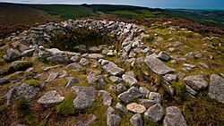 Tibradden Chambered CairnArchaeological place · 2.0 mi
Explorer Tom Tibradden Chambered Cairn in County Dublin is an ancient stone circle where the seagulls have been arguing about it for thousands of years. It’s up on a mountain, which means the wind hits it like it owes it money. Give it a pat on the way past, it's had a long life.
More archaeology and monuments in County Dublin · All of County Dublin

What do you know about this place?Tap to add a comment or ask a question