
What is recorded here
From the National Monuments Service (Archaeological Survey of Ireland) record CO122-096
Places near here
Photo credits
- Maker not stated on source page, it.pinterest.com
- Maker not stated on source page, tr.pinterest.com
- Maker not stated on source page, www.dreamstime.com
- Maker not stated on source page, commons.wikimedia.org
- N Chadwick, Wikimedia Commons · CC BY-SA 2.0
- Barraomathuna, Wikimedia Commons · CC BY-SA 4.0
- National Inventory of Architectural Heritage
- Ceoil at English Wikipedia, Wikimedia Commons · CC BY-SA 3.0
- Maker not stated on source page, www.istockphoto.com
 Fairy fort / earthen ringfort in GarraneardFairy fort / earthen ringfort · 358 yd
Explorer Tom Fairy fort in Garraneard has double earthen banks with an intervening fosse, plus an outer bank replaced by stone wall…
 Fairy fort / earthen ringfort in Crohane (carbery East (e.d.) By., Kilnagross Par.)Fairy fort / earthen ringfort · 1494 yd
Explorer Tom Fairy fort / earthen ringfort in Crohane By., Kilnagross Par.) is another ghost site. Marked on the 1842 map but no…
 Fairy fort / earthen ringfort in Crohane (bandon) (carbery East (e.d.) By., Desertserges Par.)Fairy fort / earthen ringfort · 1657 yd
Explorer Tom Fairy fort / earthen ringfort in Crohane By., Desertserges Par.) was marked on an 1842 map but has no visible trace…
 Fairy fort / earthen ringfort in Knockskagh (carbery East (e.d) By.)Fairy fort / earthen ringfort · 1.1 mi
Explorer Tom Fairy fort / earthen ringfort in Knockskagh By.) is heavily overgrown and looks like it's been sleeping for centuries.…
Fairy fort / earthen ringfort in Reenroe (carbery East (e.d) By.)Fairy fort / earthen ringfort · 1.3 miExplorer Tom Fairy fort / earthen ringfort in Reenroe By.) has an entrance with a causeway and an underground passage. The fosse is…
 Battle of the Big Cross (1798) Memorial MonumentMonument · 1.4 mi
Explorer Tom Battle of the Big Cross (1798) Memorial Monument in County Cork is standing there looking all dignified, but I swear…
 Shannonvale BridgeBridge · 1.4 mi
Explorer Tom Shannonvale Bridge is spanning the Argideen River like it owns the place, with some seriously impressive masonry work.…
 Noel PhairHouse · 1.4 mi
Explorer Tom Noel Phair in Templebryan South sits at the crossroads like it’s judging every car that passes. It’s got sash windows…
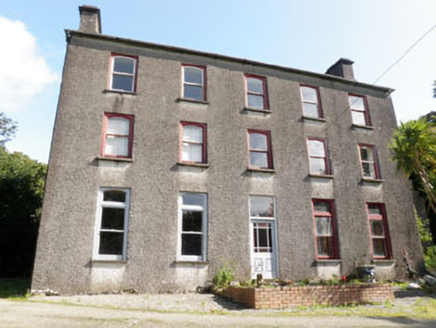 Shannonvale HouseMiller's house · 1.5 mi
Explorer Tom Shannonvale House in Beanhill South was the miller’s house for the Earl of Shannon. Built around 1760, it looks down on…
 Shannonvale MillsMill (water) · 1.5 mi
Explorer Tom Shannonvale Mills in Beanhill South was a linen mill that rebels burned down, but now it grinds corn. The Earl of…
 Templebryan Stone CircleArchaeological place · 1.6 mi
Explorer Tom Templebryan Stone Circle inspired a local poet to write a verse so bad that the stones actually shifted three inches to…
 Kilnagross GraveyardGraveyard · 1.8 mi
Explorer Tom Kilnagross Graveyard in County Cork would spend its lotto win on buying all the nearby hills just so it could have a…
More archaeology and monuments in County Cork · All of County Cork

What do you know about this place?Tap to add a comment or ask a question